White Plains geodata
White Plains (North Carolina) is a populated place; located in United States in America/New_York (GMT-4) time zone. With population of 1,041 people, there are 16019 cities with bigger population in this country. Compared to other cities in United States, 74.1% of cities are located further ↑North; 68.1% of cities are located further ←West and 67.2% of cities have lower elevation than White Plains. Note1


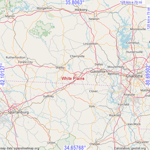
White Plains GPS coordinates[2]
35° 14' 2.472" North, 81° 23' 53.304" West
| Map corner | latitude | longitude |
|---|---|---|
| Upper-left | 35.8063°, | -82.10127° |
| Center: | 35.23402°, | -81.39814° |
| Lower-right: | 34.65768°, | -80.69502° |
| Map W x H: | 127.7×127.7 km | = 79.3×79.3mi |
| max Lat: | 71.29058° ⇑74.1% North |
| White Plains: | 35.23402° |
| min Lat: | ⇓25.9% South 19.06759° |
| min Long | White Plains | max Long |
| -171.73463° | -81.39814° | -66.98998° |
| W 68.1%⇐ | ⇒31.9% E |
Elevation
Elevation of White Plains is 272 m = 892 ft, and this is 22.8 m = 75 ft below average elevation for this country.
| Max E: |
3189 m = 10463 ft | 32.8% |
| Avg. | 294.8 m = 967 ft | |
| White Plains | 272 m = 892 ft | |
Min E: |
-60 m = -197 ft | 67.2% |
See also: United States elevation on elevation.city.
Geographical zone
White Plains is located in North temperate zone (between Tropic of Cancer and the Arctic Circle). Distance of this Northern Tropic circle is 1311.7 km =815.1 mi to South.| Distance of | km | miles | from White Plains |
|---|---|---|---|
| North Pole | 6089.4 | 3783.8 | to North |
| Arctic Circle | 3483.5 | 2164.5 | to North |
| Tropic Cancer | 1311.7 | 815.1 | to South |
| Equator | 3917.7 | 2434.3 | to South |


Nearby cities:
15 places around White Plains: (largest is in red/bold)
• Bessemer City
11.8 km =7.3 mi,  61°
61°
• Blacksburg
16.5 km =10.3 mi,  220°
220°
• Cherryville
16.2 km =10.1 mi,  6°
6°
• Clover
20.7 km =12.9 mi,  131°
131°
• Dallas
22.1 km =13.7 mi,  65°
65°
• Fallston
23.6 km =14.7 mi,  336°
336°
• Gastonia
19.4 km =12.1 mi,  80°
80°
• Grover
8.1 km =5 mi, 215°
• Kings Mountain
5.3 km =3.3 mi, 76°
• Kingstown
23.4 km =14.5 mi,  303°
303°
• Light Oak
9.1 km =5.7 mi,  308°
308°
• Patterson Springs
10.6 km =6.6 mi,  270°
270°
• Shelby
14.1 km =8.8 mi, 297°
• South Gastonia
17.6 km =10.9 mi,  95°
95°
• Tryon
13.6 km =8.5 mi,  30°
30°
Sources, notices
• [Note1] Compared only with cities in United States existing in our database
• [Src1] Map data: © OpenStreetMap contributors (CC-BY-SA)
• [Src2] Other city data from geonames.org with taken over terms of usage.
• [Src3] Geographical zone / Annual Mean Temperature by Robert A. Rohde @ Wikipedia
