Moyock geodata
Moyock (North Carolina) is a populated place; located in United States in America/New_York (GMT-4) time zone. With population of 3,759 people, there are 8512 cities with bigger population in this country. Compared to other cities in United States, 68% of cities are located further ↑North; 83.5% of cities are located further ←West and 98.1% of cities have higher elevation than Moyock. Note1
Administrative division(s):
- Level 1: North Carolina
- Level 2: Currituck County
- Level 3: Township of Moyock


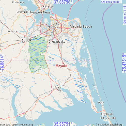
Moyock GPS coordinates[2]
36° 31' 28.56" North, 76° 10' 41.772" West
| Map corner | latitude | longitude |
|---|---|---|
| Upper-left | 37.08756°, | -76.8814° |
| Center: | 36.5246°, | -76.17827° |
| Lower-right: | 35.95751°, | -75.47515° |
| Map W x H: | 125.6×125.7 km | = 78×78.1mi |
| max Lat: | 71.29058° ⇑68% North |
| Moyock: | 36.5246° |
| min Lat: | ⇓32% South 19.06759° |
| min Long | Moyock | max Long |
| -171.73463° | -76.17827° | -66.98998° |
| W 83.5%⇐ | ⇒16.5% E |
Elevation
Elevation of Moyock is 5 m = 16 ft, and this is 289.8 m = 951 ft below average elevation for this country.
| Max E: |
3189 m = 10463 ft | 98.1% |
| Avg. | 294.8 m = 967 ft | |
| Moyock | 5 m = 16 ft | |
Min E: |
-60 m = -197 ft | 1.9% |
See also: United States elevation on elevation.city.
Geographical zone
Moyock is located in North temperate zone (between Tropic of Cancer and the Arctic Circle). Distance of this Northern Tropic circle is 1455.2 km =904.2 mi to South.| Distance of | km | miles | from Moyock |
|---|---|---|---|
| North Pole | 5945.9 | 3694.6 | to North |
| Arctic Circle | 3340 | 2075.4 | to North |
| Tropic Cancer | 1455.2 | 904.2 | to South |
| Equator | 4061.2 | 2523.5 | to South |


Nearby cities:
15 places around Moyock: (largest is in red/bold)
• Camden
21.8 km =13.5 mi,  178°
178°
• Carrollton
58 km =36 mi,  324°
324°
• Chesapeake
33.9 km =21.1 mi,  345°
345°
• Currituck
16.8 km =10.4 mi,  119°
119°
• Elizabeth City
26.4 km =16.4 mi,  194°
194°
• Gatesville
53.1 km =33 mi,  255°
255°
• Hampton
58.1 km =36.1 mi, 345°
• Hertford
45.2 km =28.1 mi,  214°
214°
• Norfolk
37.1 km =23.1 mi, 345°
• Portsmouth
36.2 km =22.5 mi,  342°
342°
• Portsmouth Heights
37.1 km =23.1 mi,  332°
332°
• South Suffolk
42.5 km =26.4 mi,  300°
300°
• Suffolk
42.8 km =26.6 mi, 301°
• Virginia Beach
40.6 km =25.2 mi,  26°
26°
• Winfall
42.5 km =26.4 mi,  216°
216°
Sources, notices
• [Note1] Compared only with cities in United States existing in our database
• [Src1] Map data: © OpenStreetMap contributors (CC-BY-SA)
• [Src2] Other city data from geonames.org with taken over terms of usage.
• [Src3] Geographical zone / Annual Mean Temperature by Robert A. Rohde @ Wikipedia
