Clover geodata
Clover (South Carolina) is a populated place; located in United States in America/New_York (GMT-4) time zone. With population of 5,744 people, there are 6578 cities with bigger population in this country. Compared to other cities in United States, 74.8% of cities are located further ↑North; 68.8% of cities are located further ←West and 61.9% of cities have lower elevation than Clover. Note1


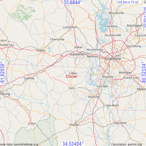
Clover GPS coordinates[2]
35° 6' 40.5" North, 81° 13' 35.256" West
| Map corner | latitude | longitude |
|---|---|---|
| Upper-left | 35.6844°, | -81.92959° |
| Center: | 35.11125°, | -81.22646° |
| Lower-right: | 34.53404°, | -80.52334° |
| Map W x H: | 127.9×127.9 km | = 79.5×79.5mi |
| max Lat: | 71.29058° ⇑74.8% North |
| Clover: | 35.11125° |
| min Lat: | ⇓25.2% South 19.06759° |
| min Long | Clover | max Long |
| -171.73463° | -81.22646° | -66.98998° |
| W 68.8%⇐ | ⇒31.2% E |
Elevation
Elevation of Clover is 248 m = 814 ft, and this is 46.8 m = 154 ft below average elevation for this country.
| Max E: |
3189 m = 10463 ft | 38.1% |
| Avg. | 294.8 m = 967 ft | |
| Clover | 248 m = 814 ft | |
Min E: |
-60 m = -197 ft | 61.9% |
See also: United States elevation on elevation.city.
Geographical zone
Clover is located in North temperate zone (between Tropic of Cancer and the Arctic Circle). Distance of this Northern Tropic circle is 1298.1 km =806.6 mi to South.| Distance of | km | miles | from Clover |
|---|---|---|---|
| North Pole | 6103.1 | 3792.3 | to North |
| Arctic Circle | 3497.2 | 2173.1 | to North |
| Tropic Cancer | 1298.1 | 806.6 | to South |
| Equator | 3904 | 2425.8 | to South |


Nearby cities:
15 places around Clover: (largest is in red/bold)
• Bessemer City
20 km =12.4 mi,  344°
344°
• Cramerton
19.8 km =12.3 mi,  44°
44°
• Gastonia
17.1 km =10.6 mi,  11°
11°
• Grover
21.5 km =13.4 mi,  289°
289°
• Kings Mountain
18.2 km =11.3 mi,  324°
324°
• Lake Wylie
16.7 km =10.4 mi,  91°
91°
• Lowell
20.7 km =12.9 mi,  32°
32°
• McAdenville
21.4 km =13.3 mi, 39°
• Newport
17.7 km =11 mi,  139°
139°
• Ranlo
21.3 km =13.2 mi,  24°
24°
• Sharon
20.6 km =12.8 mi,  210°
210°
• South Gastonia
12.2 km =7.6 mi, 8°
• Tega Cay
20.5 km =12.7 mi,  118°
118°
• White Plains
20.7 km =12.9 mi,  311°
311°
• York
13.1 km =8.1 mi,  186°
186°
Sources, notices
• [Note1] Compared only with cities in United States existing in our database
• [Src1] Map data: © OpenStreetMap contributors (CC-BY-SA)
• [Src2] Other city data from geonames.org with taken over terms of usage.
• [Src3] Geographical zone / Annual Mean Temperature by Robert A. Rohde @ Wikipedia
