Harrisburg geodata
Harrisburg (North Carolina) is a populated place; located in United States in America/New_York (GMT-4) time zone. With population of 14,539 people, there are 3328 cities with bigger population in this country. Compared to other cities in United States, 73.5% of cities are located further ↑North; 70.4% of cities are located further ←West and 50.3% of cities have higher elevation than Harrisburg. Note1


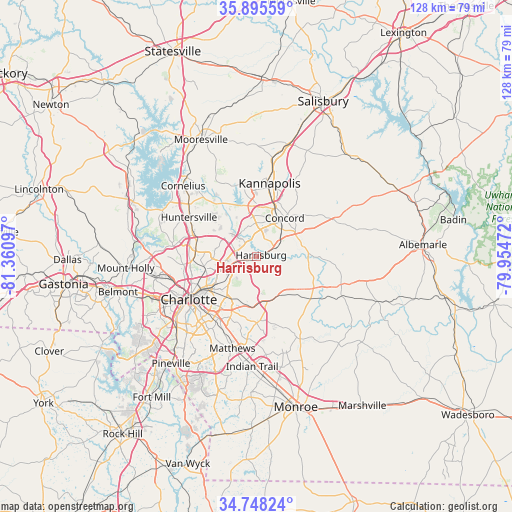
Harrisburg GPS coordinates[2]
35° 19' 26.22" North, 80° 39' 28.224" West
| Map corner | latitude | longitude |
|---|---|---|
| Upper-left | 35.89559°, | -81.36097° |
| Center: | 35.32395°, | -80.65784° |
| Lower-right: | 34.74824°, | -79.95472° |
| Map W x H: | 127.6×127.6 km | = 79.3×79.3mi |
| max Lat: | 71.29058° ⇑73.5% North |
| Harrisburg: | 35.32395° |
| min Lat: | ⇓26.5% South 19.06759° |
| min Long | Harrisburg | max Long |
| -171.73463° | -80.65784° | -66.98998° |
| W 70.4%⇐ | ⇒29.6% E |
Elevation
Elevation of Harrisburg is 197 m = 646 ft, and this is 97.8 m = 321 ft below average elevation for this country.
| Max E: |
3189 m = 10463 ft | 50.3% |
| Avg. | 294.8 m = 967 ft | |
| Harrisburg | 197 m = 646 ft | |
Min E: |
-60 m = -197 ft | 49.7% |
See also: United States elevation on elevation.city.
Geographical zone
Harrisburg is located in North temperate zone (between Tropic of Cancer and the Arctic Circle). Distance of this Northern Tropic circle is 1321.7 km =821.3 mi to South.| Distance of | km | miles | from Harrisburg |
|---|---|---|---|
| North Pole | 6079.4 | 3777.6 | to North |
| Arctic Circle | 3473.5 | 2158.3 | to North |
| Tropic Cancer | 1321.7 | 821.3 | to South |
| Equator | 3927.7 | 2440.6 | to South |


Nearby cities:
15 places around Harrisburg: (largest is in red/bold)
• Charlotte
20 km =12.4 mi,  237°
237°
• Concord
11.7 km =7.3 mi,  36°
36°
• Cornelius
25.8 km =16 mi,  314°
314°
• Enochville
22.9 km =14.2 mi,  357°
357°
• Fairview
23.3 km =14.5 mi,  152°
152°
• Hemby Bridge
24.6 km =15.3 mi,  173°
173°
• Huntersville
19.3 km =12 mi,  299°
299°
• Kannapolis
18.5 km =11.5 mi,  10°
10°
• Landis
25 km =15.5 mi, 9°
• Locust
22.3 km =13.9 mi,  108°
108°
• Matthews
23.8 km =14.8 mi,  194°
194°
• Midland
17.9 km =11.1 mi,  126°
126°
• Mint Hill
16.1 km =10 mi,  176°
176°
• Mount Pleasant
21.8 km =13.5 mi,  67°
67°
• Stanfield
23.2 km =14.4 mi,  115°
115°
Sources, notices
• [Note1] Compared only with cities in United States existing in our database
• [Src1] Map data: © OpenStreetMap contributors (CC-BY-SA)
• [Src2] Other city data from geonames.org with taken over terms of usage.
• [Src3] Geographical zone / Annual Mean Temperature by Robert A. Rohde @ Wikipedia
