Charlotte geodata
Charlotte (North Carolina) is a seat of a second-order administrative division; located in United States in America/New_York (GMT-4) time zone. With population of 827,097 people, there are 20 cities with bigger population in this country. Compared to other cities in United States, 74.1% of cities are located further ↑North; 69.8% of cities are located further ←West and 67.2% of cities have lower elevation than Charlotte. Note1


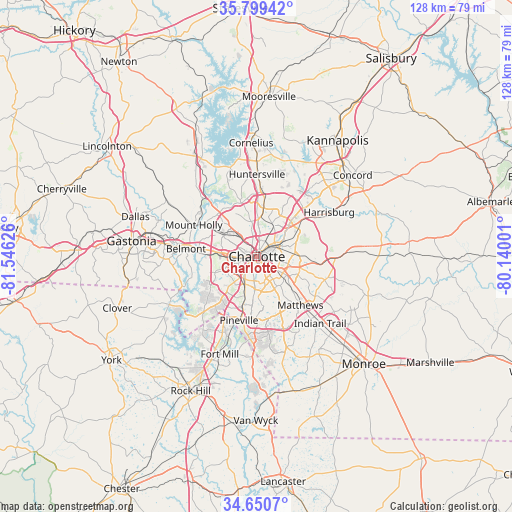
Charlotte GPS coordinates[2]
35° 13' 37.524" North, 80° 50' 35.268" West
| Map corner | latitude | longitude |
|---|---|---|
| Upper-left | 35.79942°, | -81.54626° |
| Center: | 35.22709°, | -80.84313° |
| Lower-right: | 34.6507°, | -80.14001° |
| Map W x H: | 127.7×127.7 km | = 79.3×79.3mi |
| max Lat: | 71.29058° ⇑74.1% North |
| Charlotte: | 35.22709° |
| min Lat: | ⇓25.9% South 19.06759° |
| min Long | Charlotte | max Long |
| -171.73463° | -80.84313° | -66.98998° |
| W 69.8%⇐ | ⇒30.2% E |
Elevation
Elevation of Charlotte is 272 m = 892 ft, and this is 22.8 m = 75 ft below average elevation for this country.
| Max E: |
3189 m = 10463 ft | 32.8% |
| Avg. | 294.8 m = 967 ft | |
| Charlotte | 272 m = 892 ft | |
Min E: |
-60 m = -197 ft | 67.2% |
See also: Charlotte elevation on elevation.city.
Geographical zone
Charlotte is located in North temperate zone (between Tropic of Cancer and the Arctic Circle). Distance of this Northern Tropic circle is 1311 km =814.6 mi to South.| Distance of | km | miles | from Charlotte |
|---|---|---|---|
| North Pole | 6090.2 | 3784.3 | to North |
| Arctic Circle | 3484.3 | 2165 | to North |
| Tropic Cancer | 1311 | 814.6 | to South |
| Equator | 3916.9 | 2433.8 | to South |


Nearby cities:
15 places around Charlotte: (largest is in red/bold)
• Belmont
17.7 km =11 mi,  275°
275°
• Cramerton
21.1 km =13.1 mi,  273°
273°
• Harrisburg
20 km =12.4 mi,  57°
57°
• Hemby Bridge
23.9 km =14.9 mi,  125°
125°
• Huntersville
20.4 km =12.7 mi,  0°
0°
• Indian Trail
23 km =14.3 mi,  136°
136°
• Lake Wylie
22.4 km =13.9 mi,  234°
234°
• Lowell
24 km =14.9 mi, 280°
• Matthews
16.4 km =10.2 mi, 138°
• McAdenville
21.4 km =13.3 mi, 279°
• Mint Hill
18.6 km =11.6 mi,  106°
106°
• Mount Holly
17.6 km =10.9 mi,  296°
296°
• Pineville
16.6 km =10.3 mi,  195°
195°
• Stallings
20.8 km =12.9 mi, 136°
• Weddington
24 km =14.9 mi,  161°
161°
Sources, notices
• [Note1] Compared only with cities in United States existing in our database
• [Src1] Map data: © OpenStreetMap contributors (CC-BY-SA)
• [Src2] Other city data from geonames.org with taken over terms of usage.
• [Src3] Geographical zone / Annual Mean Temperature by Robert A. Rohde @ Wikipedia
