Rougemont geodata
Rougemont (North Carolina) is a populated place; located in United States in America/New_York (GMT-4) time zone. With population of 978 people, there are 16430 cities with bigger population in this country. Compared to other cities in United States, 69.3% of cities are located further ↑North; 75.9% of cities are located further ←West and 56.8% of cities have higher elevation than Rougemont. Note1
Administrative division(s):
- Level 1: North Carolina
- Level 2: Durham County
- Level 3: Township of Mangum


Rougemont GPS coordinates[2]
36° 13' 6.528" North, 78° 55' 35.04" West
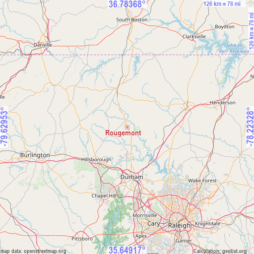
| Map corner | latitude | longitude |
|---|---|---|
| Upper-left | 36.78368°, | -79.62953° |
| Center: | 36.21848°, | -78.9264° |
| Lower-right: | 35.64917°, | -78.22328° |
| Map W x H: | 126.1×126.1 km | = 78.4×78.4mi |
| max Lat: | 71.29058° ⇑69.3% North |
| Rougemont: | 36.21848° |
| min Lat: | ⇓30.7% South 19.06759° |
| min Long | Rougemont | max Long |
| -171.73463° | -78.9264° | -66.98998° |
| W 75.9%⇐ | ⇒24.1% E |
Elevation
Elevation of Rougemont is 172 m = 564 ft, and this is 122.8 m = 403 ft below average elevation for this country.
| Max E: |
3189 m = 10463 ft | 56.8% |
| Avg. | 294.8 m = 967 ft | |
| Rougemont | 172 m = 564 ft | |
Min E: |
-60 m = -197 ft | 43.2% |
See also: United States elevation on elevation.city.
Geographical zone
Rougemont is located in North temperate zone (between Tropic of Cancer and the Arctic Circle). Distance of this Northern Tropic circle is 1421.2 km =883.1 mi to South.| Distance of | km | miles | from Rougemont |
|---|---|---|---|
| North Pole | 5979.9 | 3715.7 | to North |
| Arctic Circle | 3374.1 | 2096.6 | to North |
| Tropic Cancer | 1421.2 | 883.1 | to South |
| Equator | 4027.1 | 2502.3 | to South |


Nearby cities:
15 places around Rougemont: (largest is in red/bold)
• Butner
18 km =11.2 mi,  122°
122°
• Carrboro
36.8 km =22.9 mi,  201°
201°
• Chapel Hill
35.9 km =22.3 mi, 198°
• Creedmoor
24.1 km =15 mi, 116°
• Durham
25.1 km =15.6 mi,  174°
174°
• Efland
26.6 km =16.5 mi,  235°
235°
• Gorman
22.2 km =13.8 mi,  155°
155°
• Green Level
39 km =24.2 mi,  253°
253°
• Haw River
41.8 km =26 mi, 250°
• Hillsborough
22.3 km =13.9 mi,  224°
224°
• Mebane
33.5 km =20.8 mi, 245°
• Oxford
31.8 km =19.8 mi,  71°
71°
• Roxboro
20.1 km =12.5 mi,  345°
345°
• Woodlawn
35.2 km =21.9 mi, 250°
• Yanceyville
42.1 km =26.2 mi,  299°
299°
Sources, notices
• [Note1] Compared only with cities in United States existing in our database
• [Src1] Map data: © OpenStreetMap contributors (CC-BY-SA)
• [Src2] Other city data from geonames.org with taken over terms of usage.
• [Src3] Geographical zone / Annual Mean Temperature by Robert A. Rohde @ Wikipedia
