Durham geodata
Durham (North Carolina) is a seat of a second-order administrative division; located in United States in America/New_York (GMT-4) time zone. With population of 257,636 people, there are 87 cities with bigger population in this country. Compared to other cities in United States, 70.5% of cities are located further ↑North; 76% of cities are located further ←West and 66.4% of cities have higher elevation than Durham. Note1
Administrative division(s):
- Level 1: North Carolina
- Level 2: Durham County
- Level 3: Township of Durham


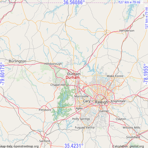
Durham GPS coordinates[2]
35° 59' 38.508" North, 78° 53' 55.032" West
| Map corner | latitude | longitude |
|---|---|---|
| Upper-left | 36.56086°, | -79.60175° |
| Center: | 35.99403°, | -78.89862° |
| Lower-right: | 35.4231°, | -78.1955° |
| Map W x H: | 126.5×126.5 km | = 78.6×78.6mi |
| max Lat: | 71.29058° ⇑70.5% North |
| Durham: | 35.99403° |
| min Lat: | ⇓29.5% South 19.06759° |
| min Long | Durham | max Long |
| -171.73463° | -78.89862° | -66.98998° |
| W 76%⇐ | ⇒24% E |
Elevation
Elevation of Durham is 121 m = 397 ft, and this is 173.8 m = 570 ft below average elevation for this country.
| Max E: |
3189 m = 10463 ft | 66.4% |
| Avg. | 294.8 m = 967 ft | |
| Durham | 121 m = 397 ft | |
Min E: |
-60 m = -197 ft | 33.6% |
See also: Durham elevation on elevation.city.
Geographical zone
Durham is located in North temperate zone (between Tropic of Cancer and the Arctic Circle). Distance of this Northern Tropic circle is 1396.2 km =867.6 mi to South.| Distance of | km | miles | from Durham |
|---|---|---|---|
| North Pole | 6004.9 | 3731.3 | to North |
| Arctic Circle | 3399 | 2112 | to North |
| Tropic Cancer | 1396.2 | 867.6 | to South |
| Equator | 4002.2 | 2486.9 | to South |


Nearby cities:
15 places around Durham: (largest is in red/bold)
• Apex
29.4 km =18.3 mi,  171°
171°
• Butner
20 km =12.4 mi,  39°
39°
• Carrboro
18.4 km =11.4 mi,  239°
239°
• Cary
24.9 km =15.5 mi,  154°
154°
• Chapel Hill
16.8 km =10.4 mi, 237°
• Creedmoor
23.8 km =14.8 mi,  53°
53°
• Efland
26.2 km =16.3 mi,  291°
291°
• Fearrington
26.1 km =16.2 mi,  217°
217°
• Fearrington Village
27.3 km =17 mi, 219°
• Gorman
8.3 km =5.2 mi,  55°
55°
• Green Level
23.6 km =14.7 mi,  181°
181°
• Hillsborough
20.2 km =12.6 mi,  296°
296°
• Morrisville
20.1 km =12.5 mi,  160°
160°
• Rougemont
25.1 km =15.6 mi,  354°
354°
• Scotts Mill
29.8 km =18.5 mi, 177°
Sources, notices
• [Note1] Compared only with cities in United States existing in our database
• [Src1] Map data: © OpenStreetMap contributors (CC-BY-SA)
• [Src2] Other city data from geonames.org with taken over terms of usage.
• [Src3] Geographical zone / Annual Mean Temperature by Robert A. Rohde @ Wikipedia
