Norlina geodata
Norlina (North Carolina) is a populated place; located in United States in America/New_York (GMT-4) time zone. With population of 1,081 people, there are 15782 cities with bigger population in this country. Compared to other cities in United States, 68.2% of cities are located further ↑North; 77.4% of cities are located further ←West and 64.7% of cities have higher elevation than Norlina. Note1
Administrative division(s):
- Level 1: North Carolina
- Level 2: Warren County
- Level 3: Township of Smith Creek


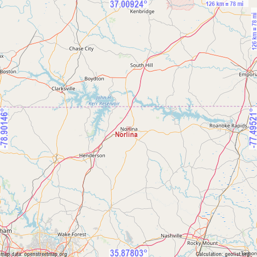
Norlina GPS coordinates[2]
36° 26' 44.52" North, 78° 11' 53.988" West
| Map corner | latitude | longitude |
|---|---|---|
| Upper-left | 37.00924°, | -78.90146° |
| Center: | 36.4457°, | -78.19833° |
| Lower-right: | 35.87803°, | -77.49521° |
| Map W x H: | 125.8×125.8 km | = 78.2×78.2mi |
| max Lat: | 71.29058° ⇑68.2% North |
| Norlina: | 36.4457° |
| min Lat: | ⇓31.8% South 19.06759° |
| min Long | Norlina | max Long |
| -171.73463° | -78.19833° | -66.98998° |
| W 77.4%⇐ | ⇒22.6% E |
Elevation
Elevation of Norlina is 130 m = 427 ft, and this is 164.8 m = 541 ft below average elevation for this country.
| Max E: |
3189 m = 10463 ft | 64.7% |
| Avg. | 294.8 m = 967 ft | |
| Norlina | 130 m = 427 ft | |
Min E: |
-60 m = -197 ft | 35.3% |
See also: United States elevation on elevation.city.
Geographical zone
Norlina is located in North temperate zone (between Tropic of Cancer and the Arctic Circle). Distance of this Northern Tropic circle is 1446.5 km =898.8 mi to South.| Distance of | km | miles | from Norlina |
|---|---|---|---|
| North Pole | 5954.7 | 3700.1 | to North |
| Arctic Circle | 3348.8 | 2080.8 | to North |
| Tropic Cancer | 1446.5 | 898.8 | to South |
| Equator | 4052.4 | 2518 | to South |


Nearby cities:
15 places around Norlina: (largest is in red/bold)
• Boydton
29.9 km =18.6 mi,  325°
325°
• Bracey
17.8 km =11.1 mi,  16°
16°
• Chase City
45.7 km =28.4 mi, 329°
• Clarksville
37.7 km =23.4 mi,  301°
301°
• Franklinton
44.8 km =27.8 mi,  211°
211°
• Henderson
22.1 km =13.7 mi,  234°
234°
• Hollister
31.6 km =19.6 mi,  131°
131°
• La Crosse
29.6 km =18.4 mi, 17°
• Littleton
25.6 km =15.9 mi,  92°
92°
• Louisburg
39.6 km =24.6 mi,  193°
193°
• Oxford
38.2 km =23.7 mi,  246°
246°
• South Henderson
24.1 km =15 mi, 230°
• South Hill
31.8 km =19.8 mi,  11°
11°
• South Rosemary
44.8 km =27.8 mi, 89°
• Warrenton
6.5 km =4 mi,  143°
143°
Sources, notices
• [Note1] Compared only with cities in United States existing in our database
• [Src1] Map data: © OpenStreetMap contributors (CC-BY-SA)
• [Src2] Other city data from geonames.org with taken over terms of usage.
• [Src3] Geographical zone / Annual Mean Temperature by Robert A. Rohde @ Wikipedia
