Louisburg geodata
Louisburg (North Carolina) is a seat of a second-order administrative division; located in United States in America/New_York (GMT-4) time zone. With population of 3,553 people, there are 8789 cities with bigger population in this country. Compared to other cities in United States, 70% of cities are located further ↑North; 77.3% of cities are located further ←West and 75.5% of cities have higher elevation than Louisburg. Note1
Administrative division(s):
- Level 1: North Carolina
- Level 2: Franklin County
- Level 3: Township of Louisburg


Louisburg GPS coordinates[2]
36° 5' 56.544" North, 78° 18' 3.996" West
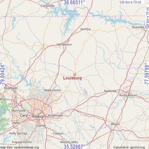
| Map corner | latitude | longitude |
|---|---|---|
| Upper-left | 36.66511°, | -79.00424° |
| Center: | 36.09904°, | -78.30111° |
| Lower-right: | 35.52887°, | -77.59799° |
| Map W x H: | 126.3×126.3 km | = 78.5×78.5mi |
| max Lat: | 71.29058° ⇑70% North |
| Louisburg: | 36.09904° |
| min Lat: | ⇓30% South 19.06759° |
| min Long | Louisburg | max Long |
| -171.73463° | -78.30111° | -66.98998° |
| W 77.3%⇐ | ⇒22.7% E |
Elevation
Elevation of Louisburg is 69 m = 226 ft, and this is 225.8 m = 741 ft below average elevation for this country.
| Max E: |
3189 m = 10463 ft | 75.5% |
| Avg. | 294.8 m = 967 ft | |
| Louisburg | 69 m = 226 ft | |
Min E: |
-60 m = -197 ft | 24.5% |
See also: United States elevation on elevation.city.
Geographical zone
Louisburg is located in North temperate zone (between Tropic of Cancer and the Arctic Circle). Distance of this Northern Tropic circle is 1407.9 km =874.8 mi to South.| Distance of | km | miles | from Louisburg |
|---|---|---|---|
| North Pole | 5993.2 | 3724 | to North |
| Arctic Circle | 3387.3 | 2104.8 | to North |
| Tropic Cancer | 1407.9 | 874.8 | to South |
| Equator | 4013.8 | 2494.1 | to South |


Nearby cities:
15 places around Louisburg: (largest is in red/bold)
• Creedmoor
34.7 km =21.6 mi,  274°
274°
• Franklinton
14.1 km =8.8 mi, 271°
• Henderson
27.1 km =16.8 mi,  341°
341°
• Middlesex
35.4 km =22 mi,  165°
165°
• Nashville
33.2 km =20.6 mi,  114°
114°
• Oxford
35.1 km =21.8 mi,  312°
312°
• Red Oak
36.1 km =22.4 mi,  100°
100°
• Rolesville
24.1 km =15 mi,  215°
215°
• South Henderson
25.1 km =15.6 mi, 337°
• Spring Hope
24.1 km =15 mi,  135°
135°
• Wake Forest
23 km =14.3 mi,  234°
234°
• Warrenton
35.8 km =22.2 mi,  21°
21°
• Wendell
35.9 km =22.3 mi,  189°
189°
• Youngsville
17.6 km =10.9 mi,  242°
242°
• Zebulon
30.6 km =19 mi,  182°
182°
Sources, notices
• [Note1] Compared only with cities in United States existing in our database
• [Src1] Map data: © OpenStreetMap contributors (CC-BY-SA)
• [Src2] Other city data from geonames.org with taken over terms of usage.
• [Src3] Geographical zone / Annual Mean Temperature by Robert A. Rohde @ Wikipedia
