Pineville geodata
Pineville (North Carolina) is a populated place; located in United States in America/New_York (GMT-4) time zone. With population of 8,429 people, there are 5062 cities with bigger population in this country. Compared to other cities in United States, 74.9% of cities are located further ↑North; 69.7% of cities are located further ←West and 56% of cities have higher elevation than Pineville. Note1


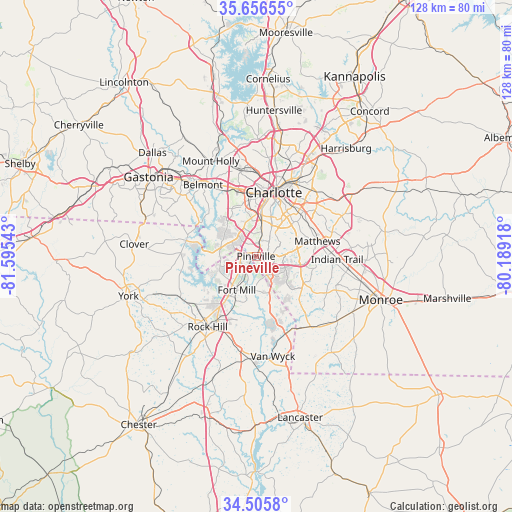
Pineville GPS coordinates[2]
35° 4' 59.52" North, 80° 53' 32.28" West
| Map corner | latitude | longitude |
|---|---|---|
| Upper-left | 35.65655°, | -81.59543° |
| Center: | 35.0832°, | -80.8923° |
| Lower-right: | 34.5058°, | -80.18918° |
| Map W x H: | 128×128 km | = 79.5×79.5mi |
| max Lat: | 71.29058° ⇑74.9% North |
| Pineville: | 35.0832° |
| min Lat: | ⇓25.1% South 19.06759° |
| min Long | Pineville | max Long |
| -171.73463° | -80.8923° | -66.98998° |
| W 69.7%⇐ | ⇒30.3% E |
Elevation
Elevation of Pineville is 176 m = 577 ft, and this is 118.8 m = 390 ft below average elevation for this country.
| Max E: |
3189 m = 10463 ft | 56% |
| Avg. | 294.8 m = 967 ft | |
| Pineville | 176 m = 577 ft | |
Min E: |
-60 m = -197 ft | 44% |
See also: United States elevation on elevation.city.
Geographical zone
Pineville is located in North temperate zone (between Tropic of Cancer and the Arctic Circle). Distance of this Northern Tropic circle is 1295 km =804.7 mi to South.| Distance of | km | miles | from Pineville |
|---|---|---|---|
| North Pole | 6106.2 | 3794.2 | to North |
| Arctic Circle | 3500.3 | 2175 | to North |
| Tropic Cancer | 1295 | 804.7 | to South |
| Equator | 3900.9 | 2423.9 | to South |


Nearby cities:
15 places around Pineville: (largest is in red/bold)
• Belmont
22.1 km =13.7 mi,  323°
323°
• Charlotte
16.6 km =10.3 mi,  15°
15°
• Fort Mill
9.7 km =6 mi,  209°
209°
• India Hook
14.5 km =9 mi,  234°
234°
• Indian Trail
20.3 km =12.6 mi,  92°
92°
• Lake Wylie
14 km =8.7 mi,  281°
281°
• Marvin
12.4 km =7.7 mi,  145°
145°
• Matthews
15.8 km =9.8 mi,  76°
76°
• Newport
21.6 km =13.4 mi,  241°
241°
• Riverview
12 km =7.5 mi,  221°
221°
• Rock Hill
21.4 km =13.3 mi, 214°
• Stallings
18.8 km =11.7 mi, 87°
• Tega Cay
14 km =8.7 mi, 242°
• Weddington
13.7 km =8.5 mi,  119°
119°
• Wesley Chapel
21.6 km =13.4 mi,  113°
113°
Sources, notices
• [Note1] Compared only with cities in United States existing in our database
• [Src1] Map data: © OpenStreetMap contributors (CC-BY-SA)
• [Src2] Other city data from geonames.org with taken over terms of usage.
• [Src3] Geographical zone / Annual Mean Temperature by Robert A. Rohde @ Wikipedia
