Rock Hill geodata
Rock Hill (South Carolina) is a populated place; located in United States in America/New_York (GMT-4) time zone. With population of 71,548 people, there are 578 cities with bigger population in this country. Compared to other cities in United States, 75.8% of cities are located further ↑North; 69.4% of cities are located further ←West and 52.8% of cities have lower elevation than Rock Hill. Note1


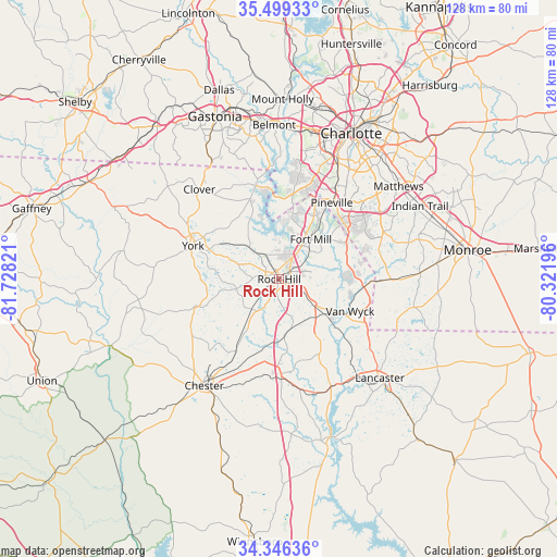
Rock Hill GPS coordinates[2]
34° 55' 29.532" North, 81° 1' 30.288" West
| Map corner | latitude | longitude |
|---|---|---|
| Upper-left | 35.49933°, | -81.72821° |
| Center: | 34.92487°, | -81.02508° |
| Lower-right: | 34.34636°, | -80.32196° |
| Map W x H: | 128.2×128.2 km | = 79.7×79.7mi |
| max Lat: | 71.29058° ⇑75.8% North |
| Rock Hill: | 34.92487° |
| min Lat: | ⇓24.2% South 19.06759° |
| min Long | Rock Hill | max Long |
| -171.73463° | -81.02508° | -66.98998° |
| W 69.4%⇐ | ⇒30.6% E |
Elevation
Elevation of Rock Hill is 209 m = 686 ft, and this is 85.8 m = 281 ft below average elevation for this country.
| Max E: |
3189 m = 10463 ft | 47.2% |
| Avg. | 294.8 m = 967 ft | |
| Rock Hill | 209 m = 686 ft | |
Min E: |
-60 m = -197 ft | 52.8% |
See also: Rock Hill elevation on elevation.city.
Geographical zone
Rock Hill is located in North temperate zone (between Tropic of Cancer and the Arctic Circle). Distance of this Northern Tropic circle is 1277.4 km =793.7 mi to South.| Distance of | km | miles | from Rock Hill |
|---|---|---|---|
| North Pole | 6123.8 | 3805.2 | to North |
| Arctic Circle | 3517.9 | 2185.9 | to North |
| Tropic Cancer | 1277.4 | 793.7 | to South |
| Equator | 3883.3 | 2413 | to South |


Nearby cities:
15 places around Rock Hill: (largest is in red/bold)
• Catawba
13.1 km =8.1 mi,  127°
127°
• Fort Lawn
27.5 km =17.1 mi,  154°
154°
• Fort Mill
11.7 km =7.3 mi,  38°
38°
• India Hook
9.2 km =5.7 mi,  1°
1°
• Jaars
26.4 km =16.4 mi,  104°
104°
• Lake Wylie
20.5 km =12.7 mi,  355°
355°
• Lesslie
7.3 km =4.5 mi,  121°
121°
• Marvin
20.6 km =12.8 mi,  68°
68°
• Newport
10 km =6.2 mi,  316°
316°
• Pineville
21.4 km =13.3 mi,  34°
34°
• Riverview
9.6 km =6 mi, 25°
• Tega Cay
11.1 km =6.9 mi, 358°
• Waxhaw
25.7 km =16 mi,  90°
90°
• Weddington
26.4 km =16.4 mi, 65°
• York
21.2 km =13.2 mi,  291°
291°
Sources, notices
• [Note1] Compared only with cities in United States existing in our database
• [Src1] Map data: © OpenStreetMap contributors (CC-BY-SA)
• [Src2] Other city data from geonames.org with taken over terms of usage.
• [Src3] Geographical zone / Annual Mean Temperature by Robert A. Rohde @ Wikipedia
