Pittsboro geodata
Pittsboro (North Carolina) is a seat of a second-order administrative division; located in United States in America/New_York (GMT-4) time zone. With population of 4,198 people, there are 7984 cities with bigger population in this country. Compared to other cities in United States, 71.7% of cities are located further ↑North; 75.4% of cities are located further ←West and 65.8% of cities have higher elevation than Pittsboro. Note1
Administrative division(s):
- Level 1: North Carolina
- Level 2: Chatham County
- Level 3: Township of Center


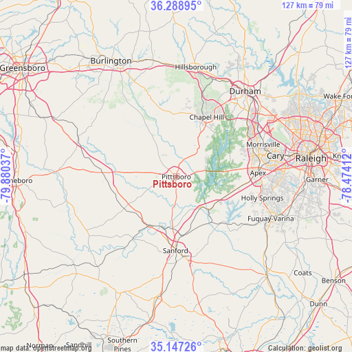
Pittsboro GPS coordinates[2]
35° 43' 12.54" North, 79° 10' 38.064" West
| Map corner | latitude | longitude |
|---|---|---|
| Upper-left | 36.28895°, | -79.88037° |
| Center: | 35.72015°, | -79.17724° |
| Lower-right: | 35.14726°, | -78.47412° |
| Map W x H: | 126.9×126.9 km | = 78.9×78.9mi |
| max Lat: | 71.29058° ⇑71.7% North |
| Pittsboro: | 35.72015° |
| min Lat: | ⇓28.3% South 19.06759° |
| min Long | Pittsboro | max Long |
| -171.73463° | -79.17724° | -66.98998° |
| W 75.4%⇐ | ⇒24.6% E |
Elevation
Elevation of Pittsboro is 124 m = 407 ft, and this is 170.8 m = 560 ft below average elevation for this country.
| Max E: |
3189 m = 10463 ft | 65.8% |
| Avg. | 294.8 m = 967 ft | |
| Pittsboro | 124 m = 407 ft | |
Min E: |
-60 m = -197 ft | 34.2% |
See also: United States elevation on elevation.city.
Geographical zone
Pittsboro is located in North temperate zone (between Tropic of Cancer and the Arctic Circle). Distance of this Northern Tropic circle is 1365.8 km =848.7 mi to South.| Distance of | km | miles | from Pittsboro |
|---|---|---|---|
| North Pole | 6035.4 | 3750.2 | to North |
| Arctic Circle | 3429.5 | 2131 | to North |
| Tropic Cancer | 1365.8 | 848.7 | to South |
| Equator | 3971.7 | 2467.9 | to South |


Nearby cities:
15 places around Pittsboro: (largest is in red/bold)
• Apex
29.5 km =18.3 mi,  87°
87°
• Broadway
31.2 km =19.4 mi,  158°
158°
• Carrboro
23 km =14.3 mi,  23°
23°
• Chapel Hill
24.1 km =15 mi,  27°
27°
• Farmville
17.1 km =10.6 mi,  193°
193°
• Fearrington
13.4 km =8.3 mi,  44°
44°
• Fearrington Village
12.2 km =7.6 mi, 40°
• Green Level
25.6 km =15.9 mi,  74°
74°
• Holly Springs
32 km =19.9 mi,  103°
103°
• Moncure
14 km =8.7 mi,  140°
140°
• Pleasant Hill
32.3 km =20.1 mi,  301°
301°
• Sanford
26.7 km =16.6 mi,  180°
180°
• Saxapahaw
28.4 km =17.6 mi,  332°
332°
• Scotts Mill
26.5 km =16.5 mi, 88°
• Siler City
25.7 km =16 mi,  270°
270°
Sources, notices
• [Note1] Compared only with cities in United States existing in our database
• [Src1] Map data: © OpenStreetMap contributors (CC-BY-SA)
• [Src2] Other city data from geonames.org with taken over terms of usage.
• [Src3] Geographical zone / Annual Mean Temperature by Robert A. Rohde @ Wikipedia
