Sanford geodata
Sanford (North Carolina) is a seat of a second-order administrative division; located in United States in America/New_York (GMT-4) time zone. With population of 29,144 people, there are 1712 cities with bigger population in this country. Compared to other cities in United States, 72.8% of cities are located further ↑North; 75.4% of cities are located further ←West and 68.3% of cities have higher elevation than Sanford. Note1


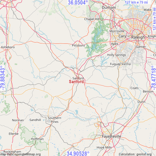
Sanford GPS coordinates[2]
35° 28' 47.568" North, 79° 10' 49.08" West
| Map corner | latitude | longitude |
|---|---|---|
| Upper-left | 36.0504°, | -79.88343° |
| Center: | 35.47988°, | -79.1803° |
| Lower-right: | 34.90528°, | -78.47718° |
| Map W x H: | 127.3×127.3 km | = 79.1×79.1mi |
| max Lat: | 71.29058° ⇑72.8% North |
| Sanford: | 35.47988° |
| min Lat: | ⇓27.2% South 19.06759° |
| min Long | Sanford | max Long |
| -171.73463° | -79.1803° | -66.98998° |
| W 75.4%⇐ | ⇒24.6% E |
Elevation
Elevation of Sanford is 111 m = 364 ft, and this is 183.8 m = 603 ft below average elevation for this country.
| Max E: |
3189 m = 10463 ft | 68.3% |
| Avg. | 294.8 m = 967 ft | |
| Sanford | 111 m = 364 ft | |
Min E: |
-60 m = -197 ft | 31.7% |
See also: United States elevation on elevation.city.
Geographical zone
Sanford is located in North temperate zone (between Tropic of Cancer and the Arctic Circle). Distance of this Northern Tropic circle is 1339.1 km =832.1 mi to South.| Distance of | km | miles | from Sanford |
|---|---|---|---|
| North Pole | 6062.1 | 3766.8 | to North |
| Arctic Circle | 3456.2 | 2147.6 | to North |
| Tropic Cancer | 1339.1 | 832.1 | to South |
| Equator | 3945 | 2451.3 | to South |


Nearby cities:
15 places around Sanford: (largest is in red/bold)
• Broadway
11.8 km =7.3 mi,  101°
101°
• Carthage
26.1 km =16.2 mi,  235°
235°
• Farmville
10.7 km =6.6 mi,  340°
340°
• Fearrington
37.6 km =23.4 mi,  14°
14°
• Fearrington Village
36.9 km =22.9 mi, 12°
• Fuquay-Varina
36.3 km =22.6 mi,  71°
71°
• Holly Springs
36.7 km =22.8 mi,  58°
58°
• Lillington
34.2 km =21.3 mi,  105°
105°
• Mamers
23.4 km =14.5 mi, 107°
• Moncure
18.4 km =11.4 mi,  30°
30°
• Pittsboro
26.7 km =16.6 mi,  0°
0°
• Robbins
37.2 km =23.1 mi,  262°
262°
• Siler City
37.2 km =23.1 mi,  316°
316°
• Vass
26.5 km =16.5 mi,  200°
200°
• Whispering Pines
30.4 km =18.9 mi,  214°
214°
Sources, notices
• [Note1] Compared only with cities in United States existing in our database
• [Src1] Map data: © OpenStreetMap contributors (CC-BY-SA)
• [Src2] Other city data from geonames.org with taken over terms of usage.
• [Src3] Geographical zone / Annual Mean Temperature by Robert A. Rohde @ Wikipedia
