Southern Pines geodata
Southern Pines (North Carolina) is a populated place; located in United States in America/New_York (GMT-4) time zone. With population of 13,539 people, there are 3544 cities with bigger population in this country. Compared to other cities in United States, 74.4% of cities are located further ↑North; 75.1% of cities are located further ←West and 59.9% of cities have higher elevation than Southern Pines. Note1


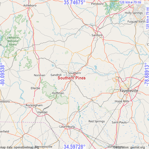
Southern Pines GPS coordinates[2]
35° 10' 26.58" North, 79° 23' 32.1" West
| Map corner | latitude | longitude |
|---|---|---|
| Upper-left | 35.74675°, | -80.09538° |
| Center: | 35.17405°, | -79.39225° |
| Lower-right: | 34.59728°, | -78.68913° |
| Map W x H: | 127.8×127.8 km | = 79.4×79.4mi |
| max Lat: | 71.29058° ⇑74.4% North |
| Southern Pines: | 35.17405° |
| min Lat: | ⇓25.6% South 19.06759° |
| min Long | Southern Pines | max Long |
| -171.73463° | -79.39225° | -66.98998° |
| W 75.1%⇐ | ⇒24.9% E |
Elevation
Elevation of Southern Pines is 155 m = 509 ft, and this is 139.8 m = 459 ft below average elevation for this country.
| Max E: |
3189 m = 10463 ft | 59.9% |
| Avg. | 294.8 m = 967 ft | |
| Southern Pines | 155 m = 509 ft | |
Min E: |
-60 m = -197 ft | 40.1% |
See also: United States elevation on elevation.city.
Geographical zone
Southern Pines is located in North temperate zone (between Tropic of Cancer and the Arctic Circle). Distance of this Northern Tropic circle is 1305.1 km =811 mi to South.| Distance of | km | miles | from Southern Pines |
|---|---|---|---|
| North Pole | 6096.1 | 3787.9 | to North |
| Arctic Circle | 3490.2 | 2168.7 | to North |
| Tropic Cancer | 1305.1 | 811 | to South |
| Equator | 3911 | 2430.2 | to South |


Nearby cities:
15 places around Southern Pines: (largest is in red/bold)
• Aberdeen
5.8 km =3.6 mi,  215°
215°
• Carthage
19.2 km =11.9 mi,  353°
353°
• Five Points
17.7 km =11 mi,  170°
170°
• Foxfire
16.3 km =10.1 mi,  270°
270°
• Hoffman
21.2 km =13.2 mi, 221°
• Pinebluff
10.2 km =6.3 mi,  225°
225°
• Pinehurst
7.4 km =4.6 mi,  288°
288°
• Raeford
26.4 km =16.4 mi,  144°
144°
• Robbins
33.9 km =21.1 mi,  328°
328°
• Seven Lakes
19.5 km =12.1 mi,  306°
306°
• Silver City
24.9 km =15.5 mi, 142°
• Taylortown
9.3 km =5.8 mi, 293°
• Vass
13.5 km =8.4 mi,  47°
47°
• Wagram
31.9 km =19.8 mi,  175°
175°
• Whispering Pines
9.3 km =5.8 mi,  11°
11°
Sources, notices
• [Note1] Compared only with cities in United States existing in our database
• [Src1] Map data: © OpenStreetMap contributors (CC-BY-SA)
• [Src2] Other city data from geonames.org with taken over terms of usage.
• [Src3] Geographical zone / Annual Mean Temperature by Robert A. Rohde @ Wikipedia
