Saint Pauls geodata
Saint Pauls (North Carolina) is a populated place; located in United States in America/New_York (GMT-4) time zone. With population of 2,035 people, there are 11847 cities with bigger population in this country. Compared to other cities in United States, 76.4% of cities are located further ↑North; 75.8% of cities are located further ←West and 78.6% of cities have higher elevation than Saint Pauls. Note1


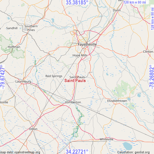
Saint Pauls GPS coordinates[2]
34° 48' 23.58" North, 78° 58' 16.104" West
| Map corner | latitude | longitude |
|---|---|---|
| Upper-left | 35.38185°, | -79.67427° |
| Center: | 34.80655°, | -78.97114° |
| Lower-right: | 34.22721°, | -78.26802° |
| Map W x H: | 128.4×128.4 km | = 79.8×79.8mi |
| max Lat: | 71.29058° ⇑76.4% North |
| Saint Pauls: | 34.80655° |
| min Lat: | ⇓23.6% South 19.06759° |
| min Long | Saint Pauls | max Long |
| -171.73463° | -78.97114° | -66.98998° |
| W 75.8%⇐ | ⇒24.2% E |
Elevation
Elevation of Saint Pauls is 53 m = 174 ft, and this is 241.8 m = 793 ft below average elevation for this country.
| Max E: |
3189 m = 10463 ft | 78.6% |
| Avg. | 294.8 m = 967 ft | |
| Saint Pauls | 53 m = 174 ft | |
Min E: |
-60 m = -197 ft | 21.4% |
See also: United States elevation on elevation.city.
Geographical zone
Saint Pauls is located in North temperate zone (between Tropic of Cancer and the Arctic Circle). Distance of this Northern Tropic circle is 1264.2 km =785.5 mi to South.| Distance of | km | miles | from Saint Pauls |
|---|---|---|---|
| North Pole | 6136.9 | 3813.3 | to North |
| Arctic Circle | 3531 | 2194.1 | to North |
| Tropic Cancer | 1264.2 | 785.5 | to South |
| Equator | 3870.1 | 2404.8 | to South |


Nearby cities:
15 places around Saint Pauls: (largest is in red/bold)
• Barker Ten Mile
14.2 km =8.8 mi,  186°
186°
• Bladenboro
34.2 km =21.3 mi,  150°
150°
• Eastover
36.2 km =22.5 mi,  25°
25°
• Fayetteville
28.6 km =17.8 mi,  17°
17°
• Hope Mills
18.4 km =11.4 mi,  7°
7°
• Lumberton
21.2 km =13.2 mi, 189°
• Maxton
35.4 km =22 mi,  257°
257°
• Pembroke
24.8 km =15.4 mi,  235°
235°
• Prospect
25 km =15.5 mi,  250°
250°
• Raeford
30.1 km =18.7 mi,  310°
310°
• Red Springs
19.4 km =12.1 mi,  272°
272°
• Rockfish
22.4 km =13.9 mi,  337°
337°
• Silver City
31.4 km =19.5 mi, 312°
• Stedman
34.2 km =21.3 mi,  47°
47°
• Vander
29.8 km =18.5 mi, 32°
Sources, notices
• [Note1] Compared only with cities in United States existing in our database
• [Src1] Map data: © OpenStreetMap contributors (CC-BY-SA)
• [Src2] Other city data from geonames.org with taken over terms of usage.
• [Src3] Geographical zone / Annual Mean Temperature by Robert A. Rohde @ Wikipedia
