Rockfish geodata
Rockfish (North Carolina) is a populated place; located in United States in America/New_York (GMT-4) time zone. With population of 3,298 people, there are 9153 cities with bigger population in this country. Compared to other cities in United States, 75.4% of cities are located further ↑North; 75.6% of cities are located further ←West and 75.6% of cities have higher elevation than Rockfish. Note1
Administrative division(s):
- Level 1: North Carolina
- Level 2: Hoke County
- Level 3: Township of McLauchlin


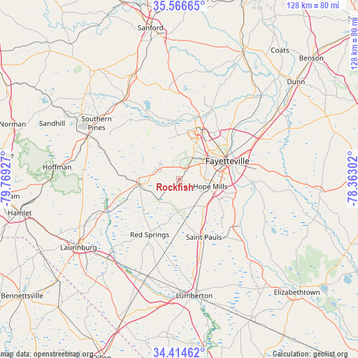
Rockfish GPS coordinates[2]
34° 59' 33.576" North, 79° 3' 58.104" West
| Map corner | latitude | longitude |
|---|---|---|
| Upper-left | 35.56665°, | -79.76927° |
| Center: | 34.99266°, | -79.06614° |
| Lower-right: | 34.41462°, | -78.36302° |
| Map W x H: | 128.1×128.1 km | = 79.6×79.6mi |
| max Lat: | 71.29058° ⇑75.4% North |
| Rockfish: | 34.99266° |
| min Lat: | ⇓24.6% South 19.06759° |
| min Long | Rockfish | max Long |
| -171.73463° | -79.06614° | -66.98998° |
| W 75.6%⇐ | ⇒24.4% E |
Elevation
Elevation of Rockfish is 68 m = 223 ft, and this is 226.8 m = 744 ft below average elevation for this country.
| Max E: |
3189 m = 10463 ft | 75.6% |
| Avg. | 294.8 m = 967 ft | |
| Rockfish | 68 m = 223 ft | |
Min E: |
-60 m = -197 ft | 24.4% |
See also: United States elevation on elevation.city.
Geographical zone
Rockfish is located in North temperate zone (between Tropic of Cancer and the Arctic Circle). Distance of this Northern Tropic circle is 1284.9 km =798.4 mi to South.| Distance of | km | miles | from Rockfish |
|---|---|---|---|
| North Pole | 6116.2 | 3800.4 | to North |
| Arctic Circle | 3510.4 | 2181.3 | to North |
| Tropic Cancer | 1284.9 | 798.4 | to South |
| Equator | 3890.8 | 2417.6 | to South |


Nearby cities:
15 places around Rockfish: (largest is in red/bold)
• Eastover
27 km =16.8 mi,  63°
63°
• Fayetteville
18.4 km =11.4 mi,  68°
68°
• Five Points
27 km =16.8 mi,  275°
275°
• Fort Bragg
17.2 km =10.7 mi,  18°
18°
• Hope Mills
11.3 km =7 mi,  102°
102°
• Prospect
32.5 km =20.2 mi,  207°
207°
• Raeford
14.5 km =9 mi,  264°
264°
• Red Springs
22.4 km =13.9 mi, 208°
• Saint Pauls
22.4 km =13.9 mi,  157°
157°
• Silver City
14.6 km =9.1 mi,  271°
271°
• Spring Lake
21.3 km =13.2 mi, 23°
• Stedman
34 km =21.1 mi,  86°
86°
• Vander
25.1 km =15.6 mi,  79°
79°
• Vass
35.3 km =21.9 mi,  326°
326°
• Wagram
29.7 km =18.5 mi,  246°
246°
Sources, notices
• [Note1] Compared only with cities in United States existing in our database
• [Src1] Map data: © OpenStreetMap contributors (CC-BY-SA)
• [Src2] Other city data from geonames.org with taken over terms of usage.
• [Src3] Geographical zone / Annual Mean Temperature by Robert A. Rohde @ Wikipedia
