Raeford geodata
Raeford (North Carolina) is a seat of a second-order administrative division; located in United States in America/New_York (GMT-4) time zone. With population of 4,860 people, there are 7307 cities with bigger population in this country. Compared to other cities in United States, 75.5% of cities are located further ↑North; 75.3% of cities are located further ←West and 73% of cities have higher elevation than Raeford. Note1
Administrative division(s):
- Level 1: North Carolina
- Level 2: Hoke County
- Level 3: Township of Raeford


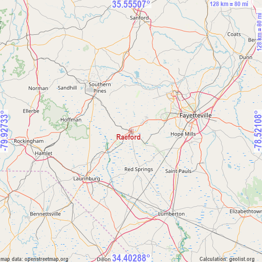
Raeford GPS coordinates[2]
34° 58' 51.6" North, 79° 13' 27.12" West
| Map corner | latitude | longitude |
|---|---|---|
| Upper-left | 35.55507°, | -79.92733° |
| Center: | 34.981°, | -79.2242° |
| Lower-right: | 34.40288°, | -78.52108° |
| Map W x H: | 128.1×128.1 km | = 79.6×79.6mi |
| max Lat: | 71.29058° ⇑75.5% North |
| Raeford: | 34.981° |
| min Lat: | ⇓24.5% South 19.06759° |
| min Long | Raeford | max Long |
| -171.73463° | -79.2242° | -66.98998° |
| W 75.3%⇐ | ⇒24.7% E |
Elevation
Elevation of Raeford is 83 m = 272 ft, and this is 211.8 m = 695 ft below average elevation for this country.
| Max E: |
3189 m = 10463 ft | 73% |
| Avg. | 294.8 m = 967 ft | |
| Raeford | 83 m = 272 ft | |
Min E: |
-60 m = -197 ft | 27% |
See also: United States elevation on elevation.city.
Geographical zone
Raeford is located in North temperate zone (between Tropic of Cancer and the Arctic Circle). Distance of this Northern Tropic circle is 1283.6 km =797.6 mi to South.| Distance of | km | miles | from Raeford |
|---|---|---|---|
| North Pole | 6117.5 | 3801.2 | to North |
| Arctic Circle | 3511.7 | 2182.1 | to North |
| Tropic Cancer | 1283.6 | 797.6 | to South |
| Equator | 3889.5 | 2416.8 | to South |


Nearby cities:
15 places around Raeford: (largest is in red/bold)
• Aberdeen
25.1 km =15.6 mi,  311°
311°
• Five Points
13.1 km =8.1 mi,  287°
287°
• Fort Bragg
26.5 km =16.5 mi,  48°
48°
• Hoffman
30 km =18.6 mi,  280°
280°
• Hope Mills
25.4 km =15.8 mi,  92°
92°
• Maxton
29.6 km =18.4 mi,  202°
202°
• Pinebluff
26.7 km =16.6 mi,  302°
302°
• Prospect
27.6 km =17.1 mi,  181°
181°
• Red Springs
18.8 km =11.7 mi,  168°
168°
• Rockfish
14.5 km =9 mi,  84°
84°
• Saint Pauls
30.1 km =18.7 mi,  130°
130°
• Silver City
1.7 km =1.1 mi,  353°
353°
• Southern Pines
26.4 km =16.4 mi,  324°
324°
• Spring Lake
30.9 km =19.2 mi, 47°
• Wagram
16.6 km =10.3 mi,  231°
231°
Sources, notices
• [Note1] Compared only with cities in United States existing in our database
• [Src1] Map data: © OpenStreetMap contributors (CC-BY-SA)
• [Src2] Other city data from geonames.org with taken over terms of usage.
• [Src3] Geographical zone / Annual Mean Temperature by Robert A. Rohde @ Wikipedia
