Silver City geodata
Silver City (North Carolina) is a populated place; located in United States in America/New_York (GMT-4) time zone. With population of 882 people, there are 17098 cities with bigger population in this country. Compared to other cities in United States, 75.4% of cities are located further ↑North; 75.3% of cities are located further ←West and 73.7% of cities have higher elevation than Silver City. Note1
Administrative division(s):
- Level 1: North Carolina
- Level 2: Hoke County
- Level 3: Township of Raeford


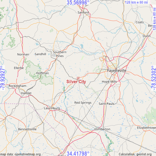
Silver City GPS coordinates[2]
34° 59' 45.6" North, 79° 13' 34.104" West
| Map corner | latitude | longitude |
|---|---|---|
| Upper-left | 35.56996°, | -79.92927° |
| Center: | 34.996°, | -79.22614° |
| Lower-right: | 34.41798°, | -78.52302° |
| Map W x H: | 128.1×128.1 km | = 79.6×79.6mi |
| max Lat: | 71.29058° ⇑75.4% North |
| Silver City: | 34.996° |
| min Lat: | ⇓24.6% South 19.06759° |
| min Long | Silver City | max Long |
| -171.73463° | -79.22614° | -66.98998° |
| W 75.3%⇐ | ⇒24.7% E |
Elevation
Elevation of Silver City is 79 m = 259 ft, and this is 215.8 m = 708 ft below average elevation for this country.
| Max E: |
3189 m = 10463 ft | 73.7% |
| Avg. | 294.8 m = 967 ft | |
| Silver City | 79 m = 259 ft | |
Min E: |
-60 m = -197 ft | 26.3% |
See also: United States elevation on elevation.city.
Geographical zone
Silver City is located in North temperate zone (between Tropic of Cancer and the Arctic Circle). Distance of this Northern Tropic circle is 1285.3 km =798.6 mi to South.| Distance of | km | miles | from Silver City |
|---|---|---|---|
| North Pole | 6115.9 | 3800.2 | to North |
| Arctic Circle | 3510 | 2181 | to North |
| Tropic Cancer | 1285.3 | 798.6 | to South |
| Equator | 3891.2 | 2417.9 | to South |


Nearby cities:
15 places around Silver City: (largest is in red/bold)
• Aberdeen
23.9 km =14.9 mi,  309°
309°
• Five Points
12.5 km =7.8 mi,  280°
280°
• Fort Bragg
25.6 km =15.9 mi,  51°
51°
• Hoffman
29.5 km =18.3 mi, 277°
• Hope Mills
25.7 km =16 mi,  96°
96°
• Maxton
31.1 km =19.3 mi,  201°
201°
• Pinebluff
25.7 km =16 mi,  299°
299°
• Prospect
29.2 km =18.1 mi,  180°
180°
• Raeford
1.7 km =1.1 mi,  173°
173°
• Red Springs
20.5 km =12.7 mi, 168°
• Rockfish
14.6 km =9.1 mi,  91°
91°
• Southern Pines
24.9 km =15.5 mi,  322°
322°
• Spring Lake
29.9 km =18.6 mi, 50°
• Vass
29.4 km =18.3 mi,  350°
350°
• Wagram
17.5 km =10.9 mi,  226°
226°
Sources, notices
• [Note1] Compared only with cities in United States existing in our database
• [Src1] Map data: © OpenStreetMap contributors (CC-BY-SA)
• [Src2] Other city data from geonames.org with taken over terms of usage.
• [Src3] Geographical zone / Annual Mean Temperature by Robert A. Rohde @ Wikipedia
