Shawnee geodata
Shawnee (Oklahoma) is a seat of a second-order administrative division; located in United States in America/Chicago (GMT-5) time zone. With population of 31,286 people, there are 1585 cities with bigger population in this country. Compared to other cities in United States, 73.5% of cities are located further ↑North; 75.5% of cities are located further →East and 76.8% of cities have lower elevation than Shawnee. Note1


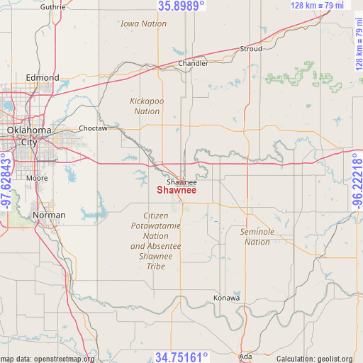
Shawnee GPS coordinates[2]
35° 19' 38.244" North, 96° 55' 31.08" West
| Map corner | latitude | longitude |
|---|---|---|
| Upper-left | 35.8989°, | -97.62843° |
| Center: | 35.32729°, | -96.9253° |
| Lower-right: | 34.75161°, | -96.22218° |
| Map W x H: | 127.6×127.6 km | = 79.3×79.3mi |
| max Lat: | 71.29058° ⇑73.5% North |
| Shawnee: | 35.32729° |
| min Lat: | ⇓26.5% South 19.06759° |
| min Long | Shawnee | max Long |
| -171.73463° | -96.9253° | -66.98998° |
| W 24.5%⇐ | ⇒75.5% E |
Elevation
Elevation of Shawnee is 326 m = 1070 ft, and this is 31.2 m = 102 ft above average elevation for this country.
| Max E: |
3189 m = 10463 ft | 23.2% |
| Shawnee | 326 m 1070 ft | |
| Avg. | 294.8 m = 967 ft | |
Min E: |
-60 m = -197 ft | 76.8% |
See also: United States elevation on elevation.city.
Geographical zone
Shawnee is located in North temperate zone (between Tropic of Cancer and the Arctic Circle). Distance of this Northern Tropic circle is 1322.1 km =821.5 mi to South.| Distance of | km | miles | from Shawnee |
|---|---|---|---|
| North Pole | 6079 | 3777.3 | to North |
| Arctic Circle | 3473.1 | 2158.1 | to North |
| Tropic Cancer | 1322.1 | 821.5 | to South |
| Equator | 3928 | 2440.7 | to South |


Nearby cities:
15 places around Shawnee: (largest is in red/bold)
• Bethel Acres
9.3 km =5.8 mi,  257°
257°
• Chandler
41.8 km =26 mi,  5°
5°
• Choctaw
36.4 km =22.6 mi,  301°
301°
• Earlsboro
12.9 km =8 mi,  120°
120°
• Harrah
28.1 km =17.5 mi,  309°
309°
• Jones
42.2 km =26.2 mi, 309°
• Maud
25.8 km =16 mi,  148°
148°
• McLoud
19.3 km =12 mi, 308°
• Meeker
19.7 km =12.2 mi, 5°
• Nicoma Park
40.4 km =25.1 mi, 296°
• Pink
19.1 km =11.9 mi,  247°
247°
• Prague
28.1 km =17.5 mi,  50°
50°
• Seminole
25.8 km =16 mi, 116°
• Tecumseh
7.8 km =4.8 mi,  187°
187°
• Wellston
42.7 km =26.5 mi,  342°
342°
Sources, notices
• [Note1] Compared only with cities in United States existing in our database
• [Src1] Map data: © OpenStreetMap contributors (CC-BY-SA)
• [Src2] Other city data from geonames.org with taken over terms of usage.
• [Src3] Geographical zone / Annual Mean Temperature by Robert A. Rohde @ Wikipedia
