Okemah geodata
Okemah (Oklahoma) is a seat of a second-order administrative division; located in United States in America/Chicago (GMT-5) time zone. With population of 3,247 people, there are 9236 cities with bigger population in this country. Compared to other cities in United States, 73% of cities are located further ↑North; 74.1% of cities are located further →East and 69% of cities have lower elevation than Okemah. Note1


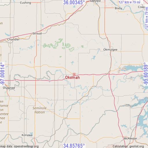
Okemah GPS coordinates[2]
35° 25' 57.324" North, 96° 18' 18.036" West
| Map corner | latitude | longitude |
|---|---|---|
| Upper-left | 36.00345°, | -97.00814° |
| Center: | 35.43259°, | -96.30501° |
| Lower-right: | 34.85765°, | -95.60189° |
| Map W x H: | 127.4×127.4 km | = 79.2×79.2mi |
| max Lat: | 71.29058° ⇑73% North |
| Okemah: | 35.43259° |
| min Lat: | ⇓27% South 19.06759° |
| min Long | Okemah | max Long |
| -171.73463° | -96.30501° | -66.98998° |
| W 25.9%⇐ | ⇒74.1% E |
Elevation
Elevation of Okemah is 281 m = 922 ft, and this is 13.8 m = 45 ft below average elevation for this country.
| Max E: |
3189 m = 10463 ft | 31% |
| Avg. | 294.8 m = 967 ft | |
| Okemah | 281 m = 922 ft | |
Min E: |
-60 m = -197 ft | 69% |
See also: United States elevation on elevation.city.
Geographical zone
Okemah is located in North temperate zone (between Tropic of Cancer and the Arctic Circle). Distance of this Northern Tropic circle is 1333.8 km =828.8 mi to South.| Distance of | km | miles | from Okemah |
|---|---|---|---|
| North Pole | 6067.3 | 3770 | to North |
| Arctic Circle | 3461.4 | 2150.8 | to North |
| Tropic Cancer | 1333.8 | 828.8 | to South |
| Equator | 3939.7 | 2448 | to South |


Nearby cities:
15 places around Okemah: (largest is in red/bold)
• Beggs
40.5 km =25.2 mi,  31°
31°
• Boley
17.5 km =10.9 mi,  292°
292°
• Bristow
44.9 km =27.9 mi,  350°
350°
• Dewar
33.1 km =20.6 mi,  85°
85°
• Henryetta
29.3 km =18.2 mi, 88°
• Holdenville
40.1 km =24.9 mi,  192°
192°
• Morris
44.7 km =27.8 mi,  64°
64°
• Okmulgee
37.7 km =23.4 mi, 55°
• Prague
34.9 km =21.7 mi,  279°
279°
• Schulter
32.8 km =20.4 mi,  73°
73°
• Seminole
40.4 km =25.1 mi,  235°
235°
• Weleetka
18.7 km =11.6 mi,  125°
125°
• Wetumka
22.4 km =13.9 mi,  165°
165°
• Wewoka
34.9 km =21.7 mi,  209°
209°
• Wilson
25.9 km =16.1 mi, 71°
Sources, notices
• [Note1] Compared only with cities in United States existing in our database
• [Src1] Map data: © OpenStreetMap contributors (CC-BY-SA)
• [Src2] Other city data from geonames.org with taken over terms of usage.
• [Src3] Geographical zone / Annual Mean Temperature by Robert A. Rohde @ Wikipedia
