Bethel Acres geodata
Bethel Acres (Oklahoma) is a populated place; located in United States in America/Chicago (GMT-5) time zone. With population of 3,101 people, there are 9462 cities with bigger population in this country. Compared to other cities in United States, 73.6% of cities are located further ↑North; 75.8% of cities are located further →East and 79.5% of cities have lower elevation than Bethel Acres. Note1


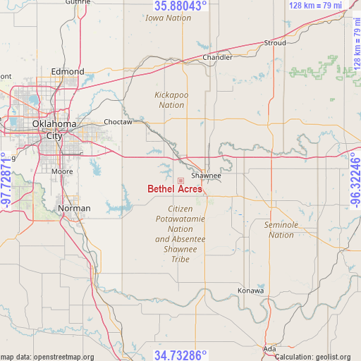
Bethel Acres GPS coordinates[2]
35° 18' 31.248" North, 97° 1' 32.088" West
| Map corner | latitude | longitude |
|---|---|---|
| Upper-left | 35.88043°, | -97.72871° |
| Center: | 35.30868°, | -97.02558° |
| Lower-right: | 34.73286°, | -96.32246° |
| Map W x H: | 127.6×127.6 km | = 79.3×79.3mi |
| max Lat: | 71.29058° ⇑73.6% North |
| Bethel Acres: | 35.30868° |
| min Lat: | ⇓26.4% South 19.06759° |
| min Long | Bethel Acres | max Long |
| -171.73463° | -97.02558° | -66.98998° |
| W 24.2%⇐ | ⇒75.8% E |
Elevation
Elevation of Bethel Acres is 348 m = 1142 ft, and this is 53.2 m = 175 ft above average elevation for this country.
| Max E: |
3189 m = 10463 ft | 20.5% |
| Bethel Acres | 348 m 1142 ft | |
| Avg. | 294.8 m = 967 ft | |
Min E: |
-60 m = -197 ft | 79.5% |
See also: United States elevation on elevation.city.
Geographical zone
Bethel Acres is located in North temperate zone (between Tropic of Cancer and the Arctic Circle). Distance of this Northern Tropic circle is 1320 km =820.2 mi to South.| Distance of | km | miles | from Bethel Acres |
|---|---|---|---|
| North Pole | 6081.1 | 3778.6 | to North |
| Arctic Circle | 3475.2 | 2159.4 | to North |
| Tropic Cancer | 1320 | 820.2 | to South |
| Equator | 3926 | 2439.5 | to South |


Nearby cities:
15 places around Bethel Acres: (largest is in red/bold)
• Choctaw
30.5 km =19 mi,  313°
313°
• Earlsboro
20.7 km =12.9 mi,  102°
102°
• Hall Park
35.5 km =22.1 mi,  257°
257°
• Harrah
23.7 km =14.7 mi,  328°
328°
• Jones
37.1 km =23.1 mi,  320°
320°
• Maud
30.1 km =18.7 mi,  131°
131°
• McLoud
15.4 km =9.6 mi,  337°
337°
• Meeker
24.3 km =15.1 mi,  27°
27°
• Midwest City
37.1 km =23.1 mi,  294°
294°
• Nicoma Park
33.7 km =20.9 mi, 306°
• Pink
10.1 km =6.3 mi,  237°
237°
• Prague
36.7 km =22.8 mi,  57°
57°
• Seminole
33.6 km =20.9 mi,  106°
106°
• Shawnee
9.3 km =5.8 mi,  77°
77°
• Tecumseh
9.9 km =6.2 mi, 125°
Sources, notices
• [Note1] Compared only with cities in United States existing in our database
• [Src1] Map data: © OpenStreetMap contributors (CC-BY-SA)
• [Src2] Other city data from geonames.org with taken over terms of usage.
• [Src3] Geographical zone / Annual Mean Temperature by Robert A. Rohde @ Wikipedia
