Pawnee geodata
Pawnee (Oklahoma) is a seat of a second-order administrative division; located in United States in America/Chicago (GMT-5) time zone. With population of 2,160 people, there are 11439 cities with bigger population in this country. Compared to other cities in United States, 68.7% of cities are located further ↑North; 75.2% of cities are located further →East and 66.7% of cities have lower elevation than Pawnee. Note1


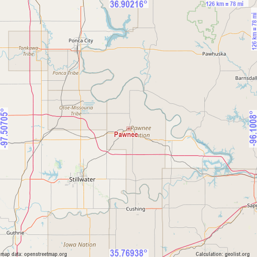
Pawnee GPS coordinates[2]
36° 20' 16.188" North, 96° 48' 14.112" West
| Map corner | latitude | longitude |
|---|---|---|
| Upper-left | 36.90216°, | -97.50705° |
| Center: | 36.33783°, | -96.80392° |
| Lower-right: | 35.76938°, | -96.1008° |
| Map W x H: | 126×126 km | = 78.3×78.3mi |
| max Lat: | 71.29058° ⇑68.7% North |
| Pawnee: | 36.33783° |
| min Lat: | ⇓31.3% South 19.06759° |
| min Long | Pawnee | max Long |
| -171.73463° | -96.80392° | -66.98998° |
| W 24.8%⇐ | ⇒75.2% E |
Elevation
Elevation of Pawnee is 270 m = 886 ft, and this is 24.8 m = 81 ft below average elevation for this country.
| Max E: |
3189 m = 10463 ft | 33.3% |
| Avg. | 294.8 m = 967 ft | |
| Pawnee | 270 m = 886 ft | |
Min E: |
-60 m = -197 ft | 66.7% |
See also: United States elevation on elevation.city.
Geographical zone
Pawnee is located in North temperate zone (between Tropic of Cancer and the Arctic Circle). Distance of this Northern Tropic circle is 1434.5 km =891.4 mi to South.| Distance of | km | miles | from Pawnee |
|---|---|---|---|
| North Pole | 5966.7 | 3707.5 | to North |
| Arctic Circle | 3360.8 | 2088.3 | to North |
| Tropic Cancer | 1434.5 | 891.4 | to South |
| Equator | 4040.4 | 2510.6 | to South |


Nearby cities:
15 places around Pawnee: (largest is in red/bold)
• Cleveland
30.4 km =18.9 mi,  95°
95°
• Cushing
39.4 km =24.5 mi,  175°
175°
• Drumright
42.9 km =26.7 mi,  154°
154°
• Fairfax
27.7 km =17.2 mi,  18°
18°
• Glencoe
16.3 km =10.1 mi,  221°
221°
• Hominy
37.6 km =23.4 mi,  76°
76°
• Mannford
46.3 km =28.8 mi,  119°
119°
• McCord
43.4 km =27 mi,  330°
330°
• Morrison
18.8 km =11.7 mi,  256°
256°
• Oilton
34.4 km =21.4 mi,  144°
144°
• Perkins
45.4 km =28.2 mi,  207°
207°
• Perry
43.7 km =27.2 mi, 262°
• Ponca City
48.1 km =29.9 mi, 328°
• Stillwater
33.6 km =20.9 mi, 222°
• Yale
26.6 km =16.5 mi,  159°
159°
Sources, notices
• [Note1] Compared only with cities in United States existing in our database
• [Src1] Map data: © OpenStreetMap contributors (CC-BY-SA)
• [Src2] Other city data from geonames.org with taken over terms of usage.
• [Src3] Geographical zone / Annual Mean Temperature by Robert A. Rohde @ Wikipedia
