Perry geodata
Perry (Oklahoma) is a seat of a second-order administrative division; located in United States in America/Chicago (GMT-5) time zone. With population of 5,097 people, there are 7077 cities with bigger population in this country. Compared to other cities in United States, 69% of cities are located further ↑North; 76.5% of cities are located further →East and 74.9% of cities have lower elevation than Perry. Note1


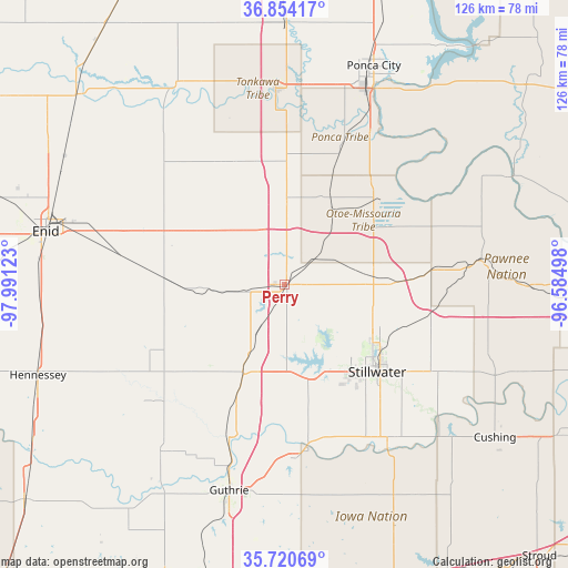
Perry GPS coordinates[2]
36° 17' 22.164" North, 97° 17' 17.16" West
| Map corner | latitude | longitude |
|---|---|---|
| Upper-left | 36.85417°, | -97.99123° |
| Center: | 36.28949°, | -97.2881° |
| Lower-right: | 35.72069°, | -96.58498° |
| Map W x H: | 126×126 km | = 78.3×78.3mi |
| max Lat: | 71.29058° ⇑69% North |
| Perry: | 36.28949° |
| min Lat: | ⇓31% South 19.06759° |
| min Long | Perry | max Long |
| -171.73463° | -97.2881° | -66.98998° |
| W 23.5%⇐ | ⇒76.5% E |
Elevation
Elevation of Perry is 312 m = 1024 ft, and this is 17.2 m = 56 ft above average elevation for this country.
| Max E: |
3189 m = 10463 ft | 25.1% |
| Perry | 312 m 1024 ft | |
| Avg. | 294.8 m = 967 ft | |
Min E: |
-60 m = -197 ft | 74.9% |
See also: United States elevation on elevation.city.
Geographical zone
Perry is located in North temperate zone (between Tropic of Cancer and the Arctic Circle). Distance of this Northern Tropic circle is 1429.1 km =888 mi to South.| Distance of | km | miles | from Perry |
|---|---|---|---|
| North Pole | 5972 | 3710.8 | to North |
| Arctic Circle | 3366.2 | 2091.7 | to North |
| Tropic Cancer | 1429.1 | 888 | to South |
| Equator | 4035 | 2507.2 | to South |


Nearby cities:
15 places around Perry: (largest is in red/bold)
• Billings
30.1 km =18.7 mi,  332°
332°
• Covington
26.8 km =16.7 mi,  274°
274°
• Crescent
46.5 km =28.9 mi,  216°
216°
• Enid
54.2 km =33.7 mi,  282°
282°
• Garber
31.3 km =19.4 mi,  301°
301°
• Glencoe
33.2 km =20.6 mi,  101°
101°
• Guthrie
47.3 km =29.4 mi,  195°
195°
• Langston
38.4 km =23.9 mi,  175°
175°
• McCord
48.6 km =30.2 mi,  27°
27°
• Morrison
25.1 km =15.6 mi,  88°
88°
• Pawnee
43.7 km =27.2 mi,  82°
82°
• Perkins
41.9 km =26 mi,  146°
146°
• Ponca City
49.8 km =30.9 mi,  21°
21°
• Stillwater
28.3 km =17.6 mi,  133°
133°
• Tonkawa
43.3 km =26.9 mi,  357°
357°
Sources, notices
• [Note1] Compared only with cities in United States existing in our database
• [Src1] Map data: © OpenStreetMap contributors (CC-BY-SA)
• [Src2] Other city data from geonames.org with taken over terms of usage.
• [Src3] Geographical zone / Annual Mean Temperature by Robert A. Rohde @ Wikipedia
