McCord geodata
McCord (Oklahoma) is a populated place; located in United States in America/Chicago (GMT-5) time zone. With population of 1,440 people, there are 13919 cities with bigger population in this country. Compared to other cities in United States, 67.4% of cities are located further ↑North; 75.8% of cities are located further →East and 77.1% of cities have lower elevation than McCord. Note1


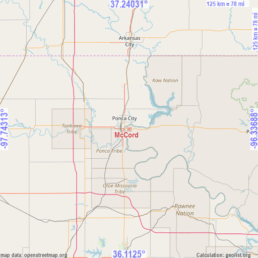
McCord GPS coordinates[2]
36° 40' 42.492" North, 97° 2' 24" West
| Map corner | latitude | longitude |
|---|---|---|
| Upper-left | 37.24031°, | -97.74313° |
| Center: | 36.67847°, | -97.04° |
| Lower-right: | 36.1125°, | -96.33688° |
| Map W x H: | 125.4×125.4 km | = 77.9×77.9mi |
| max Lat: | 71.29058° ⇑67.4% North |
| McCord: | 36.67847° |
| min Lat: | ⇓32.6% South 19.06759° |
| min Long | McCord | max Long |
| -171.73463° | -97.04° | -66.98998° |
| W 24.2%⇐ | ⇒75.8% E |
Elevation
Elevation of McCord is 328 m = 1076 ft, and this is 33.2 m = 109 ft above average elevation for this country.
| Max E: |
3189 m = 10463 ft | 22.9% |
| McCord | 328 m 1076 ft | |
| Avg. | 294.8 m = 967 ft | |
Min E: |
-60 m = -197 ft | 77.1% |
See also: United States elevation on elevation.city.
Geographical zone
McCord is located in North temperate zone (between Tropic of Cancer and the Arctic Circle). Distance of this Northern Tropic circle is 1472.3 km =914.8 mi to South.| Distance of | km | miles | from McCord |
|---|---|---|---|
| North Pole | 5928.8 | 3684 | to North |
| Arctic Circle | 3322.9 | 2064.8 | to North |
| Tropic Cancer | 1472.3 | 914.8 | to South |
| Equator | 4078.3 | 2534.1 | to South |


Nearby cities:
15 places around McCord: (largest is in red/bold)
• Arkansas City
42.6 km =26.5 mi,  0°
0°
• Billings
39.7 km =24.7 mi,  245°
245°
• Blackwell
25.8 km =16 mi,  302°
302°
• Fairfax
32.2 km =20 mi,  111°
111°
• Garber
55.6 km =34.5 mi,  241°
241°
• Glencoe
51.1 km =31.8 mi,  168°
168°
• Morrison
42.5 km =26.4 mi,  176°
176°
• Newkirk
22.7 km =14.1 mi,  356°
356°
• Pawhuska
62.7 km =39 mi,  91°
91°
• Pawnee
43.4 km =27 mi,  150°
150°
• Perry
48.6 km =30.2 mi,  207°
207°
• Ponca City
5.2 km =3.2 mi,  307°
307°
• Stillwater
62.6 km =38.9 mi, 181°
• Tonkawa
24.1 km =15 mi,  269°
269°
• Winfield
62.5 km =38.8 mi, 3°
Sources, notices
• [Note1] Compared only with cities in United States existing in our database
• [Src1] Map data: © OpenStreetMap contributors (CC-BY-SA)
• [Src2] Other city data from geonames.org with taken over terms of usage.
• [Src3] Geographical zone / Annual Mean Temperature by Robert A. Rohde @ Wikipedia
