Fairfax geodata
Fairfax (Oklahoma) is a populated place; located in United States in America/Chicago (GMT-5) time zone. With population of 1,349 people, there are 14355 cities with bigger population in this country. Compared to other cities in United States, 67.8% of cities are located further ↑North; 75% of cities are located further →East and 65% of cities have lower elevation than Fairfax. Note1


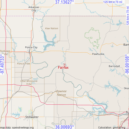
Fairfax GPS coordinates[2]
36° 34' 25.176" North, 96° 42' 15.12" West
| Map corner | latitude | longitude |
|---|---|---|
| Upper-left | 37.13627°, | -97.40733° |
| Center: | 36.57366°, | -96.7042° |
| Lower-right: | 36.00693°, | -96.00108° |
| Map W x H: | 125.6×125.6 km | = 78×78mi |
| max Lat: | 71.29058° ⇑67.8% North |
| Fairfax: | 36.57366° |
| min Lat: | ⇓32.2% South 19.06759° |
| min Long | Fairfax | max Long |
| -171.73463° | -96.7042° | -66.98998° |
| W 25%⇐ | ⇒75% E |
Elevation
Elevation of Fairfax is 262 m = 860 ft, and this is 32.8 m = 108 ft below average elevation for this country.
| Max E: |
3189 m = 10463 ft | 35% |
| Avg. | 294.8 m = 967 ft | |
| Fairfax | 262 m = 860 ft | |
Min E: |
-60 m = -197 ft | 65% |
See also: United States elevation on elevation.city.
Geographical zone
Fairfax is located in North temperate zone (between Tropic of Cancer and the Arctic Circle). Distance of this Northern Tropic circle is 1460.7 km =907.6 mi to South.| Distance of | km | miles | from Fairfax |
|---|---|---|---|
| North Pole | 5940.5 | 3691.3 | to North |
| Arctic Circle | 3334.6 | 2072 | to North |
| Tropic Cancer | 1460.7 | 907.6 | to South |
| Equator | 4066.6 | 2526.9 | to South |


Nearby cities:
15 places around Fairfax: (largest is in red/bold)
• Barnsdall
48.5 km =30.1 mi,  91°
91°
• Blackwell
57.6 km =35.8 mi,  296°
296°
• Cleveland
36.2 km =22.5 mi,  143°
143°
• Glencoe
43.2 km =26.8 mi,  207°
207°
• Hominy
32.8 km =20.4 mi,  122°
122°
• Mannford
58.1 km =36.1 mi,  147°
147°
• McCord
32.2 km =20 mi,  291°
291°
• Morrison
41 km =25.5 mi,  221°
221°
• Newkirk
46.3 km =28.8 mi,  317°
317°
• Oilton
55.5 km =34.5 mi,  168°
168°
• Pawhuska
34.4 km =21.4 mi,  72°
72°
• Pawnee
27.7 km =17.2 mi,  198°
198°
• Ponca City
37.1 km =23.1 mi, 293°
• Tonkawa
55.3 km =34.4 mi,  282°
282°
• Yale
51.1 km =31.8 mi,  179°
179°
Sources, notices
• [Note1] Compared only with cities in United States existing in our database
• [Src1] Map data: © OpenStreetMap contributors (CC-BY-SA)
• [Src2] Other city data from geonames.org with taken over terms of usage.
• [Src3] Geographical zone / Annual Mean Temperature by Robert A. Rohde @ Wikipedia
