Stratford geodata
Stratford (Oklahoma) is a populated place; located in United States in America/Chicago (GMT-5) time zone. With population of 1,535 people, there are 13530 cities with bigger population in this country. Compared to other cities in United States, 76.4% of cities are located further ↑North; 75.6% of cities are located further →East and 79.2% of cities have lower elevation than Stratford. Note1


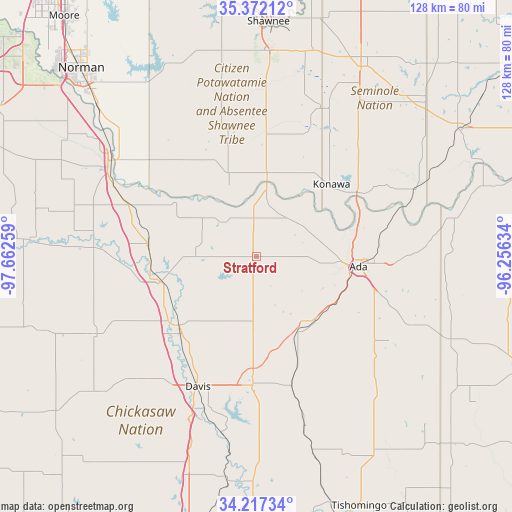
Stratford GPS coordinates[2]
34° 47' 48.3" North, 96° 57' 34.056" West
| Map corner | latitude | longitude |
|---|---|---|
| Upper-left | 35.37212°, | -97.66259° |
| Center: | 34.79675°, | -96.95946° |
| Lower-right: | 34.21734°, | -96.25634° |
| Map W x H: | 128.4×128.4 km | = 79.8×79.8mi |
| max Lat: | 71.29058° ⇑76.4% North |
| Stratford: | 34.79675° |
| min Lat: | ⇓23.6% South 19.06759° |
| min Long | Stratford | max Long |
| -171.73463° | -96.95946° | -66.98998° |
| W 24.4%⇐ | ⇒75.6% E |
Elevation
Elevation of Stratford is 346 m = 1135 ft, and this is 51.2 m = 168 ft above average elevation for this country.
| Max E: |
3189 m = 10463 ft | 20.8% |
| Stratford | 346 m 1135 ft | |
| Avg. | 294.8 m = 967 ft | |
Min E: |
-60 m = -197 ft | 79.2% |
See also: United States elevation on elevation.city.
Geographical zone
Stratford is located in North temperate zone (between Tropic of Cancer and the Arctic Circle). Distance of this Northern Tropic circle is 1263.1 km =784.9 mi to South.| Distance of | km | miles | from Stratford |
|---|---|---|---|
| North Pole | 6138 | 3814 | to North |
| Arctic Circle | 3532.1 | 2194.7 | to North |
| Tropic Cancer | 1263.1 | 784.9 | to South |
| Equator | 3869 | 2404.1 | to South |


Nearby cities:
15 places around Stratford: (largest is in red/bold)
• Ada
25.8 km =16 mi,  95°
95°
• Byng
27.8 km =17.3 mi,  75°
75°
• Davis
35.6 km =22.1 mi,  204°
204°
• Elmore City
44.4 km =27.6 mi,  244°
244°
• Konawa
26.1 km =16.2 mi,  46°
46°
• Lexington
42 km =26.1 mi,  305°
305°
• Maud
40.7 km =25.3 mi,  24°
24°
• Maysville
40.8 km =25.4 mi,  273°
273°
• Paoli
27.6 km =17.1 mi,  276°
276°
• Pauls Valley
24.8 km =15.4 mi,  255°
255°
• Purcell
43.9 km =27.3 mi,  303°
303°
• Roff
21.7 km =13.5 mi,  150°
150°
• Sulphur
32.1 km =19.9 mi,  181°
181°
• Wayne
35.1 km =21.8 mi,  292°
292°
• Wynnewood
25.3 km =15.7 mi,  227°
227°
Sources, notices
• [Note1] Compared only with cities in United States existing in our database
• [Src1] Map data: © OpenStreetMap contributors (CC-BY-SA)
• [Src2] Other city data from geonames.org with taken over terms of usage.
• [Src3] Geographical zone / Annual Mean Temperature by Robert A. Rohde @ Wikipedia
