Ada geodata
Ada (Oklahoma) is a seat of a second-order administrative division; located in United States in America/Chicago (GMT-5) time zone. With population of 17,303 people, there are 2863 cities with bigger population in this country. Compared to other cities in United States, 76.5% of cities are located further ↑North; 74.9% of cities are located further →East and 75.1% of cities have lower elevation than Ada. Note1


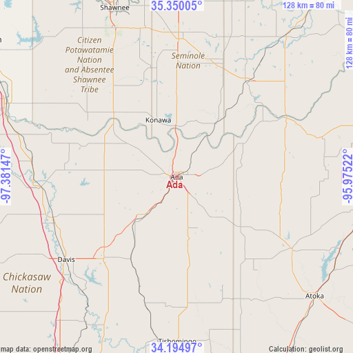
Ada GPS coordinates[2]
34° 46' 28.308" North, 96° 40' 42.024" West
| Map corner | latitude | longitude |
|---|---|---|
| Upper-left | 35.35005°, | -97.38147° |
| Center: | 34.77453°, | -96.67834° |
| Lower-right: | 34.19497°, | -95.97522° |
| Map W x H: | 128.4×128.4 km | = 79.8×79.8mi |
| max Lat: | 71.29058° ⇑76.5% North |
| Ada: | 34.77453° |
| min Lat: | ⇓23.5% South 19.06759° |
| min Long | Ada | max Long |
| -171.73463° | -96.67834° | -66.98998° |
| W 25.1%⇐ | ⇒74.9% E |
Elevation
Elevation of Ada is 314 m = 1030 ft, and this is 19.2 m = 63 ft above average elevation for this country.
| Max E: |
3189 m = 10463 ft | 24.9% |
| Ada | 314 m 1030 ft | |
| Avg. | 294.8 m = 967 ft | |
Min E: |
-60 m = -197 ft | 75.1% |
See also: United States elevation on elevation.city.
Geographical zone
Ada is located in North temperate zone (between Tropic of Cancer and the Arctic Circle). Distance of this Northern Tropic circle is 1260.6 km =783.3 mi to South.| Distance of | km | miles | from Ada |
|---|---|---|---|
| North Pole | 6140.5 | 3815.5 | to North |
| Arctic Circle | 3534.6 | 2196.3 | to North |
| Tropic Cancer | 1260.6 | 783.3 | to South |
| Equator | 3866.6 | 2402.6 | to South |


Nearby cities:
15 places around Ada: (largest is in red/bold)
• Allen
26.9 km =16.7 mi,  64°
64°
• Byng
9.7 km =6 mi,  6°
6°
• Coalgate
49.6 km =30.8 mi,  122°
122°
• Davis
50.3 km =31.3 mi,  233°
233°
• Holdenville
42.5 km =26.4 mi,  36°
36°
• Konawa
21.7 km =13.5 mi,  341°
341°
• Maud
40.6 km =25.2 mi,  347°
347°
• Paoli
53.3 km =33.1 mi,  276°
276°
• Pauls Valley
49.8 km =30.9 mi,  265°
265°
• Roff
22.1 km =13.7 mi,  222°
222°
• Seminole
50 km =31.1 mi,  0°
0°
• Stratford
25.8 km =16 mi, 275°
• Sulphur
39.8 km =24.7 mi, 221°
• Wewoka
45.9 km =28.5 mi,  21°
21°
• Wynnewood
46.8 km =29.1 mi,  251°
251°
Sources, notices
• [Note1] Compared only with cities in United States existing in our database
• [Src1] Map data: © OpenStreetMap contributors (CC-BY-SA)
• [Src2] Other city data from geonames.org with taken over terms of usage.
• [Src3] Geographical zone / Annual Mean Temperature by Robert A. Rohde @ Wikipedia
