Roff geodata
Roff (Oklahoma) is a populated place; located in United States in America/Chicago (GMT-5) time zone. With population of 720 people, there are 18500 cities with bigger population in this country. Compared to other cities in United States, 77.2% of cities are located further ↑North; 75.3% of cities are located further →East and 82.7% of cities have lower elevation than Roff. Note1


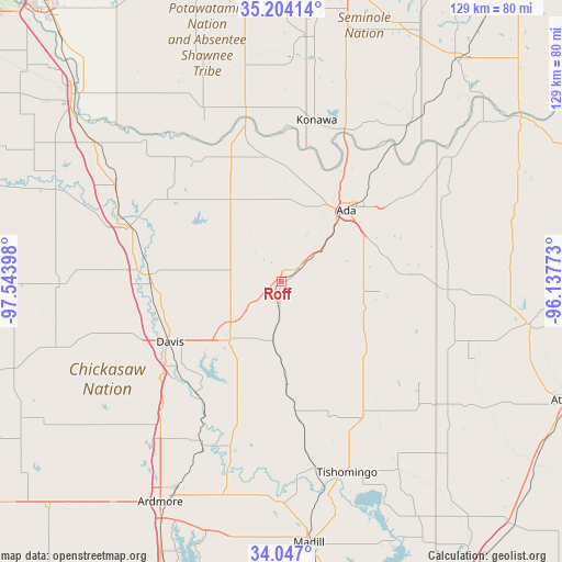
Roff GPS coordinates[2]
34° 37' 39.324" North, 96° 50' 27.06" West
| Map corner | latitude | longitude |
|---|---|---|
| Upper-left | 35.20414°, | -97.54398° |
| Center: | 34.62759°, | -96.84085° |
| Lower-right: | 34.047°, | -96.13773° |
| Map W x H: | 128.7×128.7 km | = 80×80mi |
| max Lat: | 71.29058° ⇑77.2% North |
| Roff: | 34.62759° |
| min Lat: | ⇓22.8% South 19.06759° |
| min Long | Roff | max Long |
| -171.73463° | -96.84085° | -66.98998° |
| W 24.7%⇐ | ⇒75.3% E |
Elevation
Elevation of Roff is 386 m = 1266 ft, and this is 91.2 m = 299 ft above average elevation for this country.
| Max E: |
3189 m = 10463 ft | 17.3% |
| Roff | 386 m 1266 ft | |
| Avg. | 294.8 m = 967 ft | |
Min E: |
-60 m = -197 ft | 82.7% |
See also: United States elevation on elevation.city.
Geographical zone
Roff is located in North temperate zone (between Tropic of Cancer and the Arctic Circle). Distance of this Northern Tropic circle is 1244.3 km =773.2 mi to South.| Distance of | km | miles | from Roff |
|---|---|---|---|
| North Pole | 6156.8 | 3825.7 | to North |
| Arctic Circle | 3550.9 | 2206.4 | to North |
| Tropic Cancer | 1244.3 | 773.2 | to South |
| Equator | 3850.2 | 2392.4 | to South |


Nearby cities:
15 places around Roff: (largest is in red/bold)
• Ada
22.1 km =13.7 mi,  42°
42°
• Allen
48.1 km =29.9 mi,  54°
54°
• Byng
30.5 km =19 mi,  31°
31°
• Davis
28.9 km =18 mi,  241°
241°
• Dickson
50.7 km =31.5 mi,  195°
195°
• Konawa
37.8 km =23.5 mi,  12°
12°
• Mannsville
49.2 km =30.6 mi,  184°
184°
• Paoli
44.2 km =27.5 mi,  300°
300°
• Pauls Valley
37 km =23 mi,  289°
289°
• Ravia
43.7 km =27.2 mi,  169°
169°
• Springer
44.5 km =27.7 mi,  218°
218°
• Stratford
21.7 km =13.5 mi,  330°
330°
• Sulphur
17.7 km =11 mi, 221°
• Tishomingo
46 km =28.6 mi,  161°
161°
• Wynnewood
29.7 km =18.5 mi,  273°
273°
Sources, notices
• [Note1] Compared only with cities in United States existing in our database
• [Src1] Map data: © OpenStreetMap contributors (CC-BY-SA)
• [Src2] Other city data from geonames.org with taken over terms of usage.
• [Src3] Geographical zone / Annual Mean Temperature by Robert A. Rohde @ Wikipedia
