Maud geodata
Maud (Oklahoma) is a populated place; located in United States in America/Chicago (GMT-5) time zone. With population of 1,076 people, there are 15807 cities with bigger population in this country. Compared to other cities in United States, 74.7% of cities are located further ↑North; 75.1% of cities are located further →East and 72.6% of cities have lower elevation than Maud. Note1


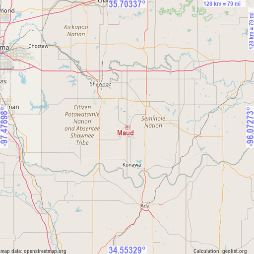
Maud GPS coordinates[2]
35° 7' 49.296" North, 96° 46' 33.06" West
| Map corner | latitude | longitude |
|---|---|---|
| Upper-left | 35.70337°, | -97.47898° |
| Center: | 35.13036°, | -96.77585° |
| Lower-right: | 34.55329°, | -96.07273° |
| Map W x H: | 127.9×127.9 km | = 79.5×79.5mi |
| max Lat: | 71.29058° ⇑74.7% North |
| Maud: | 35.13036° |
| min Lat: | ⇓25.3% South 19.06759° |
| min Long | Maud | max Long |
| -171.73463° | -96.77585° | -66.98998° |
| W 24.9%⇐ | ⇒75.1% E |
Elevation
Elevation of Maud is 299 m = 981 ft, and this is 4.2 m = 14 ft above average elevation for this country.
| Max E: |
3189 m = 10463 ft | 27.4% |
| Maud | 299 m 981 ft | |
| Avg. | 294.8 m = 967 ft | |
Min E: |
-60 m = -197 ft | 72.6% |
See also: United States elevation on elevation.city.
Geographical zone
Maud is located in North temperate zone (between Tropic of Cancer and the Arctic Circle). Distance of this Northern Tropic circle is 1300.2 km =807.9 mi to South.| Distance of | km | miles | from Maud |
|---|---|---|---|
| North Pole | 6100.9 | 3790.9 | to North |
| Arctic Circle | 3495 | 2171.7 | to North |
| Tropic Cancer | 1300.2 | 807.9 | to South |
| Equator | 3906.1 | 2427.1 | to South |


Nearby cities:
15 places around Maud: (largest is in red/bold)
• Ada
40.6 km =25.2 mi,  167°
167°
• Allen
43.3 km =26.9 mi,  130°
130°
• Bethel Acres
30.1 km =18.7 mi,  311°
311°
• Byng
31.6 km =19.6 mi,  161°
161°
• Earlsboro
15.5 km =9.6 mi,  350°
350°
• Holdenville
34.7 km =21.6 mi,  99°
99°
• Konawa
19.1 km =11.9 mi, 173°
• Meeker
43 km =26.7 mi,  344°
344°
• Pink
34.4 km =21.4 mi,  294°
294°
• Prague
40.5 km =25.2 mi,  11°
11°
• Seminole
14.2 km =8.8 mi,  42°
42°
• Shawnee
25.8 km =16 mi,  328°
328°
• Stratford
40.7 km =25.3 mi,  204°
204°
• Tecumseh
20.4 km =12.7 mi, 314°
• Wewoka
25.9 km =16.1 mi,  83°
83°
Sources, notices
• [Note1] Compared only with cities in United States existing in our database
• [Src1] Map data: © OpenStreetMap contributors (CC-BY-SA)
• [Src2] Other city data from geonames.org with taken over terms of usage.
• [Src3] Geographical zone / Annual Mean Temperature by Robert A. Rohde @ Wikipedia
