Eastover geodata
Eastover (South Carolina) is a populated place; located in United States in America/New_York (GMT-4) time zone. With population of 817 people, there are 17655 cities with bigger population in this country. Compared to other cities in United States, 81.1% of cities are located further ↑North; 70.3% of cities are located further ←West and 77.7% of cities have higher elevation than Eastover. Note1


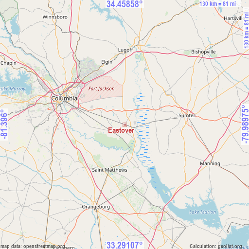
Eastover GPS coordinates[2]
33° 52' 36.552" North, 80° 41' 34.332" West
| Map corner | latitude | longitude |
|---|---|---|
| Upper-left | 34.45858°, | -81.396° |
| Center: | 33.87682°, | -80.69287° |
| Lower-right: | 33.29107°, | -79.98975° |
| Map W x H: | 129.8×129.8 km | = 80.7×80.7mi |
| max Lat: | 71.29058° ⇑81.1% North |
| Eastover: | 33.87682° |
| min Lat: | ⇓18.9% South 19.06759° |
| min Long | Eastover | max Long |
| -171.73463° | -80.69287° | -66.98998° |
| W 70.3%⇐ | ⇒29.7% E |
Elevation
Elevation of Eastover is 57 m = 187 ft, and this is 237.8 m = 780 ft below average elevation for this country.
| Max E: |
3189 m = 10463 ft | 77.7% |
| Avg. | 294.8 m = 967 ft | |
| Eastover | 57 m = 187 ft | |
Min E: |
-60 m = -197 ft | 22.3% |
See also: United States elevation on elevation.city.
Geographical zone
Eastover is located in North temperate zone (between Tropic of Cancer and the Arctic Circle). Distance of this Northern Tropic circle is 1160.8 km =721.3 mi to South.| Distance of | km | miles | from Eastover |
|---|---|---|---|
| North Pole | 6240.3 | 3877.5 | to North |
| Arctic Circle | 3634.4 | 2258.3 | to North |
| Tropic Cancer | 1160.8 | 721.3 | to South |
| Equator | 3766.7 | 2340.5 | to South |


Nearby cities:
15 places around Eastover: (largest is in red/bold)
• Cane Savannah
22.6 km =14 mi,  82°
82°
• Cherryvale
23.4 km =14.5 mi,  67°
67°
• Dalzell
28.8 km =17.9 mi,  57°
57°
• Gadsden
7.6 km =4.7 mi,  242°
242°
• Hopkins
17.3 km =10.7 mi,  280°
280°
• Millwood
29.2 km =18.1 mi, 82°
• Oak Grove
27.6 km =17.1 mi,  246°
246°
• Oakland
22.2 km =13.8 mi, 57°
• Pinewood
26.1 km =16.2 mi,  125°
125°
• Privateer
26.2 km =16.3 mi,  100°
100°
• Saint Matthews
24.8 km =15.4 mi,  198°
198°
• Stateburg
17.1 km =10.6 mi, 58°
• Wedgefield
16.2 km =10.1 mi, 83°
• Wedgewood
16.7 km =10.4 mi,  87°
87°
• Woodfield
29.9 km =18.6 mi,  312°
312°
Sources, notices
• [Note1] Compared only with cities in United States existing in our database
• [Src1] Map data: © OpenStreetMap contributors (CC-BY-SA)
• [Src2] Other city data from geonames.org with taken over terms of usage.
• [Src3] Geographical zone / Annual Mean Temperature by Robert A. Rohde @ Wikipedia
