Oak Grove geodata
Oak Grove (South Carolina) is a populated place; located in United States in America/New_York (GMT-4) time zone. With population of 8,183 people, there are 5203 cities with bigger population in this country. Compared to other cities in United States, 81.7% of cities are located further ↑North; 69.5% of cities are located further ←West and 68.9% of cities have higher elevation than Oak Grove. Note1


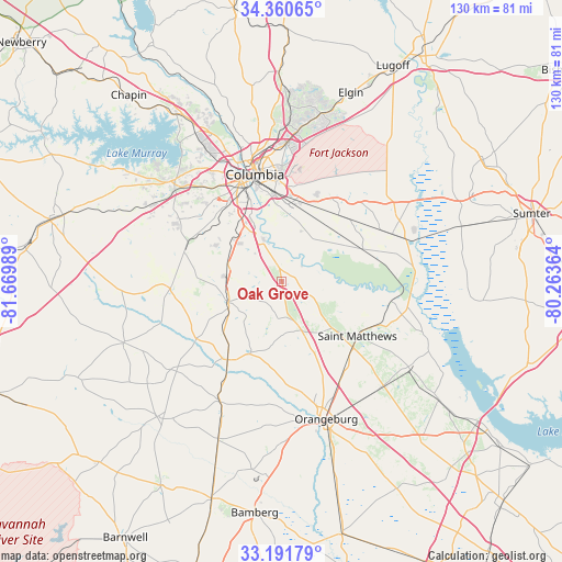
Oak Grove GPS coordinates[2]
33° 46' 41.556" North, 80° 58' 0.336" West
| Map corner | latitude | longitude |
|---|---|---|
| Upper-left | 34.36065°, | -81.66989° |
| Center: | 33.77821°, | -80.96676° |
| Lower-right: | 33.19179°, | -80.26364° |
| Map W x H: | 130×130 km | = 80.8×80.8mi |
| max Lat: | 71.29058° ⇑81.7% North |
| Oak Grove: | 33.77821° |
| min Lat: | ⇓18.3% South 19.06759° |
| min Long | Oak Grove | max Long |
| -171.73463° | -80.96676° | -66.98998° |
| W 69.5%⇐ | ⇒30.5% E |
Elevation
Elevation of Oak Grove is 107 m = 351 ft, and this is 187.8 m = 616 ft below average elevation for this country.
| Max E: |
3189 m = 10463 ft | 68.9% |
| Avg. | 294.8 m = 967 ft | |
| Oak Grove | 107 m = 351 ft | |
Min E: |
-60 m = -197 ft | 31.1% |
See also: United States elevation on elevation.city.
Geographical zone
Oak Grove is located in North temperate zone (between Tropic of Cancer and the Arctic Circle). Distance of this Northern Tropic circle is 1149.9 km =714.5 mi to South.| Distance of | km | miles | from Oak Grove |
|---|---|---|---|
| North Pole | 6251.3 | 3884.4 | to North |
| Arctic Circle | 3645.4 | 2265.1 | to North |
| Tropic Cancer | 1149.9 | 714.5 | to South |
| Equator | 3755.8 | 2333.7 | to South |


Nearby cities:
15 places around Oak Grove: (largest is in red/bold)
• Cayce
23.1 km =14.4 mi,  334°
334°
• Columbia
25.5 km =15.8 mi,  345°
345°
• Eastover
27.6 km =17.1 mi,  66°
66°
• Forest Acres
26.9 km =16.7 mi,  355°
355°
• Gadsden
20 km =12.4 mi, 67°
• Gaston
13.1 km =8.1 mi,  289°
289°
• Hopkins
16.3 km =10.1 mi,  30°
30°
• North
22 km =13.7 mi,  214°
214°
• Pelion
25.8 km =16 mi,  266°
266°
• Pineridge
19.4 km =12.1 mi,  319°
319°
• Saint Matthews
21.5 km =13.4 mi,  125°
125°
• South Congaree
21.5 km =13.4 mi,  313°
313°
• Springdale
24 km =14.9 mi, 326°
• Swansea
12.9 km =8 mi,  249°
249°
• West Columbia
25.9 km =16.1 mi,  337°
337°
Sources, notices
• [Note1] Compared only with cities in United States existing in our database
• [Src1] Map data: © OpenStreetMap contributors (CC-BY-SA)
• [Src2] Other city data from geonames.org with taken over terms of usage.
• [Src3] Geographical zone / Annual Mean Temperature by Robert A. Rohde @ Wikipedia
