Ware Shoals geodata
Ware Shoals (South Carolina) is a populated place; located in United States in America/New_York (GMT-4) time zone. With population of 2,175 people, there are 11403 cities with bigger population in this country. Compared to other cities in United States, 78.1% of cities are located further ↑North; 64.8% of cities are located further ←West and 50.3% of cities have higher elevation than Ware Shoals. Note1


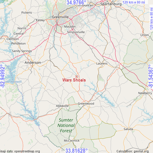
Ware Shoals GPS coordinates[2]
34° 23' 54.42" North, 82° 14' 48.444" West
| Map corner | latitude | longitude |
|---|---|---|
| Upper-left | 34.9766°, | -82.94992° |
| Center: | 34.39845°, | -82.24679° |
| Lower-right: | 33.81628°, | -81.54367° |
| Map W x H: | 129×129 km | = 80.2×80.2mi |
| max Lat: | 71.29058° ⇑78.1% North |
| Ware Shoals: | 34.39845° |
| min Lat: | ⇓21.9% South 19.06759° |
| min Long | Ware Shoals | max Long |
| -171.73463° | -82.24679° | -66.98998° |
| W 64.8%⇐ | ⇒35.2% E |
Elevation
Elevation of Ware Shoals is 197 m = 646 ft, and this is 97.8 m = 321 ft below average elevation for this country.
| Max E: |
3189 m = 10463 ft | 50.3% |
| Avg. | 294.8 m = 967 ft | |
| Ware Shoals | 197 m = 646 ft | |
Min E: |
-60 m = -197 ft | 49.7% |
See also: United States elevation on elevation.city.
Geographical zone
Ware Shoals is located in North temperate zone (between Tropic of Cancer and the Arctic Circle). Distance of this Northern Tropic circle is 1218.8 km =757.3 mi to South.| Distance of | km | miles | from Ware Shoals |
|---|---|---|---|
| North Pole | 6182.3 | 3841.5 | to North |
| Arctic Circle | 3576.4 | 2222.3 | to North |
| Tropic Cancer | 1218.8 | 757.3 | to South |
| Equator | 3824.7 | 2376.6 | to South |


Nearby cities:
15 places around Ware Shoals: (largest is in red/bold)
• Abbeville
27.3 km =17 mi,  206°
206°
• Belton
26.6 km =16.5 mi,  301°
301°
• Clinton
34.6 km =21.5 mi,  76°
76°
• Due West
14.8 km =9.2 mi,  240°
240°
• Fountain Inn
32.6 km =20.3 mi,  8°
8°
• Gray Court
26.3 km =16.3 mi,  27°
27°
• Greenwood
23.9 km =14.9 mi,  160°
160°
• Honea Path
14.3 km =8.9 mi,  291°
291°
• Lake Secession
34.3 km =21.3 mi,  248°
248°
• Laurens
24.1 km =15 mi,  62°
62°
• Ninety Six
32.2 km =20 mi,  140°
140°
• Promised Land
30 km =18.6 mi,  178°
178°
• Watts Mills
27.3 km =17 mi, 61°
• West Pelzer
34.2 km =21.3 mi,  323°
323°
• Williamston
32.4 km =20.1 mi, 319°
Sources, notices
• [Note1] Compared only with cities in United States existing in our database
• [Src1] Map data: © OpenStreetMap contributors (CC-BY-SA)
• [Src2] Other city data from geonames.org with taken over terms of usage.
• [Src3] Geographical zone / Annual Mean Temperature by Robert A. Rohde @ Wikipedia
