Clinton geodata
Clinton (South Carolina) is a populated place; located in United States in America/New_York (GMT-4) time zone. With population of 8,637 people, there are 4954 cities with bigger population in this country. Compared to other cities in United States, 77.8% of cities are located further ↑North; 65.9% of cities are located further ←West and 51.7% of cities have lower elevation than Clinton. Note1


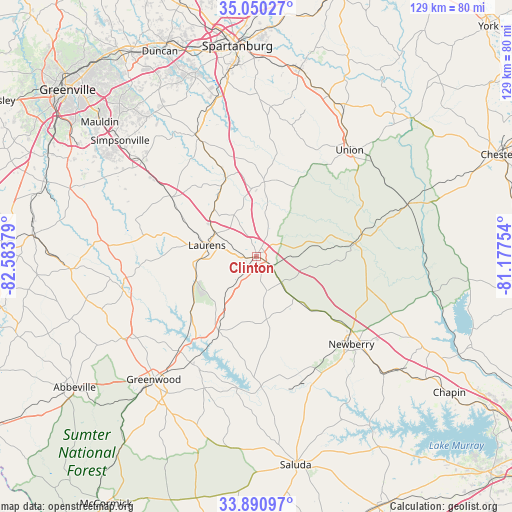
Clinton GPS coordinates[2]
34° 28' 21.468" North, 81° 52' 50.376" West
| Map corner | latitude | longitude |
|---|---|---|
| Upper-left | 35.05027°, | -82.58379° |
| Center: | 34.47263°, | -81.88066° |
| Lower-right: | 33.89097°, | -81.17754° |
| Map W x H: | 128.9×128.9 km | = 80.1×80.1mi |
| max Lat: | 71.29058° ⇑77.8% North |
| Clinton: | 34.47263° |
| min Lat: | ⇓22.2% South 19.06759° |
| min Long | Clinton | max Long |
| -171.73463° | -81.88066° | -66.98998° |
| W 65.9%⇐ | ⇒34.1% E |
Elevation
Elevation of Clinton is 205 m = 673 ft, and this is 89.8 m = 295 ft below average elevation for this country.
| Max E: |
3189 m = 10463 ft | 48.3% |
| Avg. | 294.8 m = 967 ft | |
| Clinton | 205 m = 673 ft | |
Min E: |
-60 m = -197 ft | 51.7% |
See also: United States elevation on elevation.city.
Geographical zone
Clinton is located in North temperate zone (between Tropic of Cancer and the Arctic Circle). Distance of this Northern Tropic circle is 1227.1 km =762.5 mi to South.| Distance of | km | miles | from Clinton |
|---|---|---|---|
| North Pole | 6174.1 | 3836.4 | to North |
| Arctic Circle | 3568.2 | 2217.2 | to North |
| Tropic Cancer | 1227.1 | 762.5 | to South |
| Equator | 3833 | 2381.7 | to South |


Nearby cities:
15 places around Clinton: (largest is in red/bold)
• Buffalo
33.4 km =20.8 mi,  32°
32°
• Enoree
21.9 km =13.6 mi,  339°
339°
• Fountain Inn
37.6 km =23.4 mi,  309°
309°
• Gray Court
26.1 km =16.2 mi, 305°
• Greenwood
40.2 km =25 mi,  219°
219°
• Joanna
9 km =5.6 mi,  135°
135°
• Laurens
12.6 km =7.8 mi,  283°
283°
• Monarch Mill
38.3 km =23.8 mi,  44°
44°
• Newberry
32.6 km =20.3 mi,  132°
132°
• Ninety Six
35.6 km =22.1 mi,  201°
201°
• Union
35.8 km =22.2 mi, 41°
• Ware Shoals
34.6 km =21.5 mi,  256°
256°
• Watts Mills
10.8 km =6.7 mi,  296°
296°
• Whitmire
24.9 km =15.5 mi,  82°
82°
• Woodruff
33 km =20.5 mi,  334°
334°
Sources, notices
• [Note1] Compared only with cities in United States existing in our database
• [Src1] Map data: © OpenStreetMap contributors (CC-BY-SA)
• [Src2] Other city data from geonames.org with taken over terms of usage.
• [Src3] Geographical zone / Annual Mean Temperature by Robert A. Rohde @ Wikipedia
