York geodata
York (South Carolina) is a seat of a second-order administrative division; located in United States in America/New_York (GMT-4) time zone. With population of 8,009 people, there are 5274 cities with bigger population in this country. Compared to other cities in United States, 75.4% of cities are located further ↑North; 68.7% of cities are located further ←West and 58.6% of cities have lower elevation than York. Note1


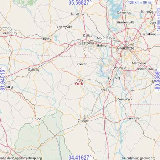
York GPS coordinates[2]
34° 59' 39.48" North, 81° 14' 31.272" West
| Map corner | latitude | longitude |
|---|---|---|
| Upper-left | 35.56827°, | -81.94515° |
| Center: | 34.9943°, | -81.24202° |
| Lower-right: | 34.41627°, | -80.5389° |
| Map W x H: | 128.1×128.1 km | = 79.6×79.6mi |
| max Lat: | 71.29058° ⇑75.4% North |
| York: | 34.9943° |
| min Lat: | ⇓24.6% South 19.06759° |
| min Long | York | max Long |
| -171.73463° | -81.24202° | -66.98998° |
| W 68.7%⇐ | ⇒31.3% E |
Elevation
Elevation of York is 233 m = 764 ft, and this is 61.8 m = 203 ft below average elevation for this country.
| Max E: |
3189 m = 10463 ft | 41.4% |
| Avg. | 294.8 m = 967 ft | |
| York | 233 m = 764 ft | |
Min E: |
-60 m = -197 ft | 58.6% |
See also: United States elevation on elevation.city.
Geographical zone
York is located in North temperate zone (between Tropic of Cancer and the Arctic Circle). Distance of this Northern Tropic circle is 1285.1 km =798.5 mi to South.| Distance of | km | miles | from York |
|---|---|---|---|
| North Pole | 6116.1 | 3800.4 | to North |
| Arctic Circle | 3510.2 | 2181.1 | to North |
| Tropic Cancer | 1285.1 | 798.5 | to South |
| Equator | 3891 | 2417.8 | to South |


Nearby cities:
15 places around York: (largest is in red/bold)
• Blacksburg
28.6 km =17.8 mi,  299°
299°
• Clover
13.1 km =8.1 mi,  6°
6°
• Fort Mill
27.1 km =16.8 mi,  86°
86°
• Gastonia
30.2 km =18.8 mi, 9°
• Grover
27.6 km =17.1 mi,  316°
316°
• India Hook
20.1 km =12.5 mi, 85°
• Kings Mountain
29.3 km =18.2 mi,  342°
342°
• Lake Wylie
22.1 km =13.7 mi,  54°
54°
• Lesslie
28.5 km =17.7 mi,  113°
113°
• Newport
12.9 km =8 mi, 92°
• Riverview
23.9 km =14.9 mi, 87°
• Rock Hill
21.2 km =13.2 mi, 111°
• Sharon
10.2 km =6.3 mi,  241°
241°
• South Gastonia
25.2 km =15.7 mi, 7°
• Tega Cay
19.8 km =12.3 mi,  80°
80°
Sources, notices
• [Note1] Compared only with cities in United States existing in our database
• [Src1] Map data: © OpenStreetMap contributors (CC-BY-SA)
• [Src2] Other city data from geonames.org with taken over terms of usage.
• [Src3] Geographical zone / Annual Mean Temperature by Robert A. Rohde @ Wikipedia
