Union geodata
Union (South Carolina) is a seat of a second-order administrative division; located in United States in America/New_York (GMT-4) time zone. With population of 8,045 people, there are 5261 cities with bigger population in this country. Compared to other cities in United States, 76.8% of cities are located further ↑North; 67% of cities are located further ←West and 50.3% of cities have higher elevation than Union. Note1


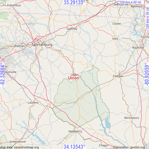
Union GPS coordinates[2]
34° 42' 55.476" North, 81° 37' 25.356" West
| Map corner | latitude | longitude |
|---|---|---|
| Upper-left | 35.29135°, | -82.32684° |
| Center: | 34.71541°, | -81.62371° |
| Lower-right: | 34.13543°, | -80.92059° |
| Map W x H: | 128.5×128.5 km | = 79.8×79.8mi |
| max Lat: | 71.29058° ⇑76.8% North |
| Union: | 34.71541° |
| min Lat: | ⇓23.2% South 19.06759° |
| min Long | Union | max Long |
| -171.73463° | -81.62371° | -66.98998° |
| W 67%⇐ | ⇒33% E |
Elevation
Elevation of Union is 197 m = 646 ft, and this is 97.8 m = 321 ft below average elevation for this country.
| Max E: |
3189 m = 10463 ft | 50.3% |
| Avg. | 294.8 m = 967 ft | |
| Union | 197 m = 646 ft | |
Min E: |
-60 m = -197 ft | 49.7% |
See also: United States elevation on elevation.city.
Geographical zone
Union is located in North temperate zone (between Tropic of Cancer and the Arctic Circle). Distance of this Northern Tropic circle is 1254.1 km =779.3 mi to South.| Distance of | km | miles | from Union |
|---|---|---|---|
| North Pole | 6147.1 | 3819.6 | to North |
| Arctic Circle | 3541.2 | 2200.4 | to North |
| Tropic Cancer | 1254.1 | 779.3 | to South |
| Equator | 3860 | 2398.5 | to South |


Nearby cities:
15 places around Union: (largest is in red/bold)
• Buffalo
5.6 km =3.5 mi,  281°
281°
• Chester
37.4 km =23.2 mi,  91°
91°
• Clifton
34.3 km =21.3 mi,  328°
328°
• Clinton
35.8 km =22.2 mi,  221°
221°
• Converse
36.3 km =22.6 mi, 327°
• Cowpens
37.3 km =23.2 mi, 333°
• Enoree
31.9 km =19.8 mi,  258°
258°
• Gayle Mill
35.1 km =21.8 mi, 92°
• Jonesville
14.4 km =8.9 mi,  338°
338°
• Monarch Mill
3.5 km =2.2 mi, 88°
• Pacolet
24 km =14.9 mi, 328°
• Pacolet Mills
25.5 km =15.8 mi, 334°
• Roebuck
36.2 km =22.5 mi,  300°
300°
• Sharon
36.8 km =22.9 mi,  44°
44°
• Whitmire
23.7 km =14.7 mi,  177°
177°
Sources, notices
• [Note1] Compared only with cities in United States existing in our database
• [Src1] Map data: © OpenStreetMap contributors (CC-BY-SA)
• [Src2] Other city data from geonames.org with taken over terms of usage.
• [Src3] Geographical zone / Annual Mean Temperature by Robert A. Rohde @ Wikipedia
