Gallaway geodata
Gallaway (Tennessee) is a populated place; located in United States in America/Chicago (GMT-5) time zone. With population of 658 people, there are 19101 cities with bigger population in this country. Compared to other cities in United States, 73.5% of cities are located further ↑North; 57.9% of cities are located further →East and 72.1% of cities have higher elevation than Gallaway. Note1


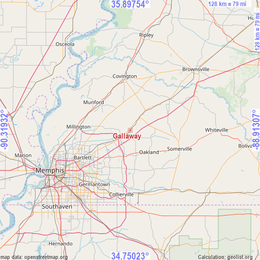
Gallaway GPS coordinates[2]
35° 19' 33.312" North, 89° 36' 58.284" West
| Map corner | latitude | longitude |
|---|---|---|
| Upper-left | 35.89754°, | -90.31932° |
| Center: | 35.32592°, | -89.61619° |
| Lower-right: | 34.75023°, | -88.91307° |
| Map W x H: | 127.6×127.6 km | = 79.3×79.3mi |
| max Lat: | 71.29058° ⇑73.5% North |
| Gallaway: | 35.32592° |
| min Lat: | ⇓26.5% South 19.06759° |
| min Long | Gallaway | max Long |
| -171.73463° | -89.61619° | -66.98998° |
| W 42.1%⇐ | ⇒57.9% E |
Elevation
Elevation of Gallaway is 88 m = 289 ft, and this is 206.8 m = 678 ft below average elevation for this country.
| Max E: |
3189 m = 10463 ft | 72.1% |
| Avg. | 294.8 m = 967 ft | |
| Gallaway | 88 m = 289 ft | |
Min E: |
-60 m = -197 ft | 27.9% |
See also: United States elevation on elevation.city.
Geographical zone
Gallaway is located in North temperate zone (between Tropic of Cancer and the Arctic Circle). Distance of this Northern Tropic circle is 1322 km =821.5 mi to South.| Distance of | km | miles | from Gallaway |
|---|---|---|---|
| North Pole | 6079.2 | 3777.4 | to North |
| Arctic Circle | 3473.3 | 2158.2 | to North |
| Tropic Cancer | 1322 | 821.5 | to South |
| Equator | 3927.9 | 2440.7 | to South |


Nearby cities:
15 places around Gallaway: (largest is in red/bold)
• Arlington
5.3 km =3.3 mi,  231°
231°
• Atoka
19.5 km =12.1 mi,  311°
311°
• Bartlett
27 km =16.8 mi,  240°
240°
• Brighton
20.2 km =12.6 mi,  330°
330°
• Collierville
31.9 km =19.8 mi,  187°
187°
• Covington
26.6 km =16.5 mi,  354°
354°
• Hickory Withe
9.4 km =5.8 mi,  164°
164°
• Lakeland
15.5 km =9.6 mi, 226°
• Mason
12.2 km =7.6 mi,  38°
38°
• Millington
25.6 km =15.9 mi,  273°
273°
• Munford
22.7 km =14.1 mi, 307°
• Oakland
14.2 km =8.8 mi,  139°
139°
• Piperton
31.2 km =19.4 mi,  180°
180°
• Rossville
31.6 km =19.6 mi,  167°
167°
• Somerville
25.8 km =16 mi,  110°
110°
Sources, notices
• [Note1] Compared only with cities in United States existing in our database
• [Src1] Map data: © OpenStreetMap contributors (CC-BY-SA)
• [Src2] Other city data from geonames.org with taken over terms of usage.
• [Src3] Geographical zone / Annual Mean Temperature by Robert A. Rohde @ Wikipedia
