Collierville geodata
Collierville (Tennessee) is a populated place; located in United States in America/Chicago (GMT-5) time zone. With population of 48,863 people, there are 980 cities with bigger population in this country. Compared to other cities in United States, 75.2% of cities are located further ↑North; 58.1% of cities are located further →East and 67.1% of cities have higher elevation than Collierville. Note1


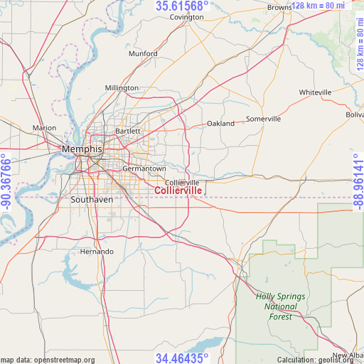
Collierville GPS coordinates[2]
35° 2' 31.344" North, 89° 39' 52.308" West
| Map corner | latitude | longitude |
|---|---|---|
| Upper-left | 35.61568°, | -90.36766° |
| Center: | 35.04204°, | -89.66453° |
| Lower-right: | 34.46435°, | -88.96141° |
| Map W x H: | 128×128 km | = 79.5×79.5mi |
| max Lat: | 71.29058° ⇑75.2% North |
| Collierville: | 35.04204° |
| min Lat: | ⇓24.8% South 19.06759° |
| min Long | Collierville | max Long |
| -171.73463° | -89.66453° | -66.98998° |
| W 41.9%⇐ | ⇒58.1% E |
Elevation
Elevation of Collierville is 117 m = 384 ft, and this is 177.8 m = 583 ft below average elevation for this country.
| Max E: |
3189 m = 10463 ft | 67.1% |
| Avg. | 294.8 m = 967 ft | |
| Collierville | 117 m = 384 ft | |
Min E: |
-60 m = -197 ft | 32.9% |
See also: Collierville elevation on elevation.city.
Geographical zone
Collierville is located in North temperate zone (between Tropic of Cancer and the Arctic Circle). Distance of this Northern Tropic circle is 1290.4 km =801.8 mi to South.| Distance of | km | miles | from Collierville |
|---|---|---|---|
| North Pole | 6110.8 | 3797.1 | to North |
| Arctic Circle | 3504.9 | 2177.8 | to North |
| Tropic Cancer | 1290.4 | 801.8 | to South |
| Equator | 3896.3 | 2421 | to South |


Nearby cities:
15 places around Collierville: (largest is in red/bold)
• Arlington
28.3 km =17.6 mi,  0°
0°
• Bartlett
26.3 km =16.3 mi,  313°
313°
• Byhalia
19 km =11.8 mi,  187°
187°
• Gallaway
31.9 km =19.8 mi,  7°
7°
• Germantown
14.1 km =8.8 mi,  290°
290°
• Hickory Withe
23.5 km =14.6 mi,  17°
17°
• Horn Lake
35.1 km =21.8 mi,  254°
254°
• Lakeland
22.1 km =13.7 mi,  341°
341°
• Moscow
23.8 km =14.8 mi,  84°
84°
• New South Memphis
36 km =22.4 mi,  277°
277°
• Oakland
24.8 km =15.4 mi,  33°
33°
• Olive Branch
17.5 km =10.9 mi,  239°
239°
• Piperton
3.9 km =2.4 mi,  85°
85°
• Rossville
11.1 km =6.9 mi, 86°
• Southaven
32.2 km =20 mi,  259°
259°
Sources, notices
• [Note1] Compared only with cities in United States existing in our database
• [Src1] Map data: © OpenStreetMap contributors (CC-BY-SA)
• [Src2] Other city data from geonames.org with taken over terms of usage.
• [Src3] Geographical zone / Annual Mean Temperature by Robert A. Rohde @ Wikipedia
