Millington geodata
Millington (Tennessee) is a populated place; located in United States in America/Chicago (GMT-5) time zone. With population of 11,027 people, there are 4172 cities with bigger population in this country. Compared to other cities in United States, 73.5% of cities are located further ↑North; 58.7% of cities are located further →East and 73.3% of cities have higher elevation than Millington. Note1


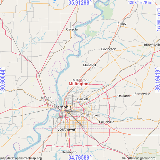
Millington GPS coordinates[2]
35° 20' 29.292" North, 89° 53' 50.316" West
| Map corner | latitude | longitude |
|---|---|---|
| Upper-left | 35.91298°, | -90.60044° |
| Center: | 35.34147°, | -89.89731° |
| Lower-right: | 34.76589°, | -89.19419° |
| Map W x H: | 127.5×127.5 km | = 79.2×79.2mi |
| max Lat: | 71.29058° ⇑73.5% North |
| Millington: | 35.34147° |
| min Lat: | ⇓26.5% South 19.06759° |
| min Long | Millington | max Long |
| -171.73463° | -89.89731° | -66.98998° |
| W 41.3%⇐ | ⇒58.7% E |
Elevation
Elevation of Millington is 81 m = 266 ft, and this is 213.8 m = 701 ft below average elevation for this country.
| Max E: |
3189 m = 10463 ft | 73.3% |
| Avg. | 294.8 m = 967 ft | |
| Millington | 81 m = 266 ft | |
Min E: |
-60 m = -197 ft | 26.7% |
See also: United States elevation on elevation.city.
Geographical zone
Millington is located in North temperate zone (between Tropic of Cancer and the Arctic Circle). Distance of this Northern Tropic circle is 1323.7 km =822.5 mi to South.| Distance of | km | miles | from Millington |
|---|---|---|---|
| North Pole | 6077.5 | 3776.4 | to North |
| Arctic Circle | 3471.6 | 2157.2 | to North |
| Tropic Cancer | 1323.7 | 822.5 | to South |
| Equator | 3929.6 | 2441.7 | to South |


Nearby cities:
15 places around Millington: (largest is in red/bold)
• Arlington
22 km =13.7 mi,  103°
103°
• Atoka
15.5 km =9.6 mi,  44°
44°
• Bartlett
15.4 km =9.6 mi,  172°
172°
• Brighton
22.2 km =13.8 mi, 44°
• Gallaway
25.6 km =15.9 mi,  93°
93°
• Germantown
29.4 km =18.3 mi,  164°
164°
• Hickory Withe
30 km =18.6 mi,  111°
111°
• Joiner
29.2 km =18.1 mi,  309°
309°
• Lakeland
18.8 km =11.7 mi,  130°
130°
• Marion
30.6 km =19 mi,  242°
242°
• Memphis
25.4 km =15.8 mi,  212°
212°
• Munford
14.1 km =8.8 mi,  31°
31°
• New South Memphis
31.8 km =19.8 mi, 207°
• Turrell
33 km =20.5 mi,  277°
277°
• Wilson
28.4 km =17.6 mi,  332°
332°
Sources, notices
• [Note1] Compared only with cities in United States existing in our database
• [Src1] Map data: © OpenStreetMap contributors (CC-BY-SA)
• [Src2] Other city data from geonames.org with taken over terms of usage.
• [Src3] Geographical zone / Annual Mean Temperature by Robert A. Rohde @ Wikipedia
