Piperton geodata
Piperton (Tennessee) is a populated place; located in United States in America/Chicago (GMT-5) time zone. With population of 1,629 people, there are 13178 cities with bigger population in this country. Compared to other cities in United States, 75.2% of cities are located further ↑North; 57.9% of cities are located further →East and 68% of cities have higher elevation than Piperton. Note1


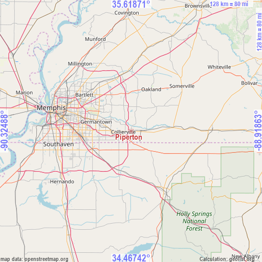
Piperton GPS coordinates[2]
35° 2' 42.324" North, 89° 37' 18.3" West
| Map corner | latitude | longitude |
|---|---|---|
| Upper-left | 35.61871°, | -90.32488° |
| Center: | 35.04509°, | -89.62175° |
| Lower-right: | 34.46742°, | -88.91863° |
| Map W x H: | 128×128 km | = 79.5×79.5mi |
| max Lat: | 71.29058° ⇑75.2% North |
| Piperton: | 35.04509° |
| min Lat: | ⇓24.8% South 19.06759° |
| min Long | Piperton | max Long |
| -171.73463° | -89.62175° | -66.98998° |
| W 42.1%⇐ | ⇒57.9% E |
Elevation
Elevation of Piperton is 112 m = 367 ft, and this is 182.8 m = 600 ft below average elevation for this country.
| Max E: |
3189 m = 10463 ft | 68% |
| Avg. | 294.8 m = 967 ft | |
| Piperton | 112 m = 367 ft | |
Min E: |
-60 m = -197 ft | 32% |
See also: United States elevation on elevation.city.
Geographical zone
Piperton is located in North temperate zone (between Tropic of Cancer and the Arctic Circle). Distance of this Northern Tropic circle is 1290.7 km =802 mi to South.| Distance of | km | miles | from Piperton |
|---|---|---|---|
| North Pole | 6110.4 | 3796.8 | to North |
| Arctic Circle | 3504.5 | 2177.6 | to North |
| Tropic Cancer | 1290.7 | 802 | to South |
| Equator | 3896.6 | 2421.2 | to South |


Nearby cities:
15 places around Piperton: (largest is in red/bold)
• Arlington
28.2 km =17.5 mi,  352°
352°
• Bartlett
29 km =18 mi,  307°
307°
• Byhalia
20.2 km =12.6 mi,  198°
198°
• Collierville
3.9 km =2.4 mi,  265°
265°
• Gallaway
31.2 km =19.4 mi,  0°
0°
• Germantown
17.8 km =11.1 mi,  285°
285°
• Hickory Withe
22.3 km =13.9 mi,  7°
7°
• Holly Springs
34.7 km =21.6 mi,  152°
152°
• Lakeland
23.3 km =14.5 mi,  332°
332°
• Moscow
19.9 km =12.4 mi,  84°
84°
• Oakland
22.6 km =14 mi,  25°
25°
• Olive Branch
21.1 km =13.1 mi,  243°
243°
• Rossville
7.2 km =4.5 mi,  87°
87°
• Somerville
33.1 km =20.6 mi,  48°
48°
• Southaven
36.1 km =22.4 mi,  260°
260°
Sources, notices
• [Note1] Compared only with cities in United States existing in our database
• [Src1] Map data: © OpenStreetMap contributors (CC-BY-SA)
• [Src2] Other city data from geonames.org with taken over terms of usage.
• [Src3] Geographical zone / Annual Mean Temperature by Robert A. Rohde @ Wikipedia
