Bartlett geodata
Bartlett (Tennessee) is a populated place; located in United States in America/Chicago (GMT-5) time zone. With population of 58,579 people, there are 775 cities with bigger population in this country. Compared to other cities in United States, 74.3% of cities are located further ↑North; 58.6% of cities are located further →East and 72.3% of cities have higher elevation than Bartlett. Note1


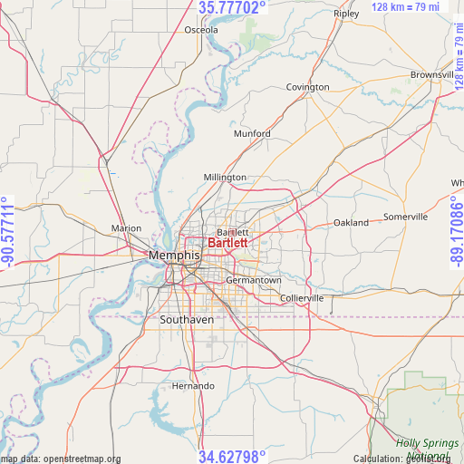
Bartlett GPS coordinates[2]
35° 12' 16.308" North, 89° 52' 26.328" West
| Map corner | latitude | longitude |
|---|---|---|
| Upper-left | 35.77702°, | -90.57711° |
| Center: | 35.20453°, | -89.87398° |
| Lower-right: | 34.62798°, | -89.17086° |
| Map W x H: | 127.8×127.8 km | = 79.4×79.4mi |
| max Lat: | 71.29058° ⇑74.3% North |
| Bartlett: | 35.20453° |
| min Lat: | ⇓25.7% South 19.06759° |
| min Long | Bartlett | max Long |
| -171.73463° | -89.87398° | -66.98998° |
| W 41.4%⇐ | ⇒58.6% E |
Elevation
Elevation of Bartlett is 87 m = 285 ft, and this is 207.8 m = 682 ft below average elevation for this country.
| Max E: |
3189 m = 10463 ft | 72.3% |
| Avg. | 294.8 m = 967 ft | |
| Bartlett | 87 m = 285 ft | |
Min E: |
-60 m = -197 ft | 27.7% |
See also: Bartlett elevation on elevation.city.
Geographical zone
Bartlett is located in North temperate zone (between Tropic of Cancer and the Arctic Circle). Distance of this Northern Tropic circle is 1308.5 km =813.1 mi to South.| Distance of | km | miles | from Bartlett |
|---|---|---|---|
| North Pole | 6092.7 | 3785.8 | to North |
| Arctic Circle | 3486.8 | 2166.6 | to North |
| Tropic Cancer | 1308.5 | 813.1 | to South |
| Equator | 3914.4 | 2432.3 | to South |


Nearby cities:
15 places around Bartlett: (largest is in red/bold)
• Arlington
21.8 km =13.5 mi,  62°
62°
• Atoka
27.7 km =17.2 mi,  18°
18°
• Collierville
26.3 km =16.3 mi,  133°
133°
• Gallaway
27 km =16.8 mi, 60°
• Germantown
14.3 km =8.9 mi,  156°
156°
• Hickory Withe
26.3 km =16.3 mi,  80°
80°
• Lakeland
12.5 km =7.8 mi, 76°
• Memphis
17 km =10.6 mi,  248°
248°
• Millington
15.4 km =9.6 mi,  352°
352°
• Munford
27.7 km =17.2 mi,  11°
11°
• New South Memphis
21.2 km =13.2 mi,  231°
231°
• Olive Branch
27.3 km =17 mi,  171°
171°
• Piperton
29 km =18 mi, 127°
• Southaven
27.1 km =16.8 mi,  207°
207°
• West Memphis
29 km =18 mi,  257°
257°
Sources, notices
• [Note1] Compared only with cities in United States existing in our database
• [Src1] Map data: © OpenStreetMap contributors (CC-BY-SA)
• [Src2] Other city data from geonames.org with taken over terms of usage.
• [Src3] Geographical zone / Annual Mean Temperature by Robert A. Rohde @ Wikipedia
