Greeneville geodata
Greeneville (Tennessee) is a seat of a second-order administrative division; located in United States in America/New_York (GMT-4) time zone. With population of 15,094 people, there are 3231 cities with bigger population in this country. Compared to other cities in United States, 69.6% of cities are located further ↑North; 62.5% of cities are located further ←West and 87% of cities have lower elevation than Greeneville. Note1


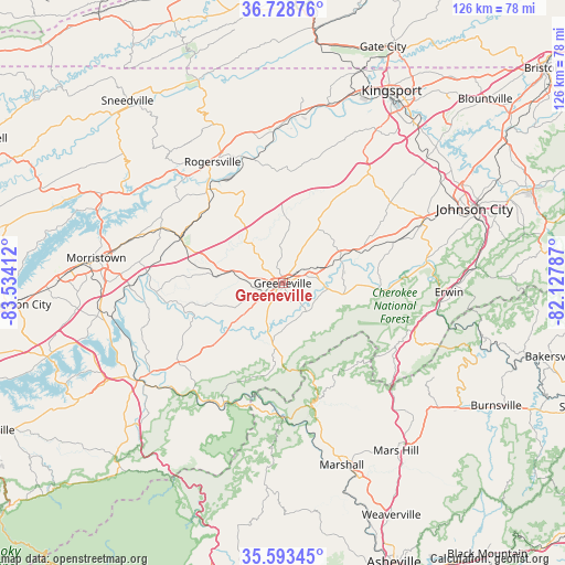
Greeneville GPS coordinates[2]
36° 9' 47.376" North, 82° 49' 51.564" West
| Map corner | latitude | longitude |
|---|---|---|
| Upper-left | 36.72876°, | -83.53412° |
| Center: | 36.16316°, | -82.83099° |
| Lower-right: | 35.59345°, | -82.12787° |
| Map W x H: | 126.2×126.2 km | = 78.4×78.4mi |
| max Lat: | 71.29058° ⇑69.6% North |
| Greeneville: | 36.16316° |
| min Lat: | ⇓30.4% South 19.06759° |
| min Long | Greeneville | max Long |
| -171.73463° | -82.83099° | -66.98998° |
| W 62.5%⇐ | ⇒37.5% E |
Elevation
Elevation of Greeneville is 469 m = 1539 ft, and this is 174.2 m = 572 ft above average elevation for this country.
| Max E: |
3189 m = 10463 ft | 13% |
| Greeneville | 469 m 1539 ft | |
| Avg. | 294.8 m = 967 ft | |
Min E: |
-60 m = -197 ft | 87% |
See also: United States elevation on elevation.city.
Geographical zone
Greeneville is located in North temperate zone (between Tropic of Cancer and the Arctic Circle). Distance of this Northern Tropic circle is 1415 km =879.2 mi to South.| Distance of | km | miles | from Greeneville |
|---|---|---|---|
| North Pole | 5986.1 | 3719.6 | to North |
| Arctic Circle | 3380.2 | 2100.4 | to North |
| Tropic Cancer | 1415 | 879.2 | to South |
| Equator | 4021 | 2498.5 | to South |


Nearby cities:
15 places around Greeneville: (largest is in red/bold)
• Banner Hill
36.7 km =22.8 mi,  95°
95°
• Bulls Gap
25.1 km =15.6 mi,  294°
294°
• Church Hill
41.3 km =25.7 mi,  14°
14°
• Erwin
37.2 km =23.1 mi,  93°
93°
• Fall Branch
33.9 km =21.1 mi,  33°
33°
• Hot Springs
30.1 km =18.7 mi,  180°
180°
• Jonesborough
35.2 km =21.9 mi,  65°
65°
• Midway
39.6 km =24.6 mi, 67°
• Mooresburg
41 km =25.5 mi,  299°
299°
• Mosheim
11.8 km =7.3 mi,  284°
284°
• Newport
38.8 km =24.1 mi,  235°
235°
• Rogersville
31.3 km =19.4 mi,  330°
330°
• Surgoinsville
34.3 km =21.3 mi,  356°
356°
• Telford
27.4 km =17 mi, 69°
• Tusculum
6.6 km =4.1 mi,  78°
78°
Sources, notices
• [Note1] Compared only with cities in United States existing in our database
• [Src1] Map data: © OpenStreetMap contributors (CC-BY-SA)
• [Src2] Other city data from geonames.org with taken over terms of usage.
• [Src3] Geographical zone / Annual Mean Temperature by Robert A. Rohde @ Wikipedia
