Mosheim geodata
Mosheim (Tennessee) is a populated place; located in United States in America/New_York (GMT-4) time zone. With population of 2,343 people, there are 10984 cities with bigger population in this country. Compared to other cities in United States, 69.5% of cities are located further ↑North; 62.1% of cities are located further ←West and 83% of cities have lower elevation than Mosheim. Note1


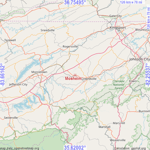
Mosheim GPS coordinates[2]
36° 11' 22.344" North, 82° 57' 30.564" West
| Map corner | latitude | longitude |
|---|---|---|
| Upper-left | 36.75495°, | -83.66162° |
| Center: | 36.18954°, | -82.95849° |
| Lower-right: | 35.62002°, | -82.25537° |
| Map W x H: | 126.2×126.2 km | = 78.4×78.4mi |
| max Lat: | 71.29058° ⇑69.5% North |
| Mosheim: | 36.18954° |
| min Lat: | ⇓30.5% South 19.06759° |
| min Long | Mosheim | max Long |
| -171.73463° | -82.95849° | -66.98998° |
| W 62.1%⇐ | ⇒37.9% E |
Elevation
Elevation of Mosheim is 390 m = 1280 ft, and this is 95.2 m = 312 ft above average elevation for this country.
| Max E: |
3189 m = 10463 ft | 17% |
| Mosheim | 390 m 1280 ft | |
| Avg. | 294.8 m = 967 ft | |
Min E: |
-60 m = -197 ft | 83% |
See also: United States elevation on elevation.city.
Geographical zone
Mosheim is located in North temperate zone (between Tropic of Cancer and the Arctic Circle). Distance of this Northern Tropic circle is 1418 km =881.1 mi to South.| Distance of | km | miles | from Mosheim |
|---|---|---|---|
| North Pole | 5983.2 | 3717.8 | to North |
| Arctic Circle | 3377.3 | 2098.6 | to North |
| Tropic Cancer | 1418 | 881.1 | to South |
| Equator | 4023.9 | 2500.3 | to South |


Nearby cities:
15 places around Mosheim: (largest is in red/bold)
• Bean Station
33.8 km =21 mi,  300°
300°
• Bulls Gap
13.7 km =8.5 mi, 303°
• Church Hill
43 km =26.7 mi,  30°
30°
• Fall Branch
39.3 km =24.4 mi,  49°
49°
• Greeneville
11.8 km =7.3 mi,  104°
104°
• Hot Springs
34.9 km =21.7 mi,  160°
160°
• Mooresburg
29.8 km =18.5 mi,  305°
305°
• Morristown
30.3 km =18.8 mi,  275°
275°
• Newport
32.2 km =20 mi,  219°
219°
• Rogersville
24.6 km =15.3 mi,  350°
350°
• Sneedville
44.4 km =27.6 mi,  328°
328°
• Surgoinsville
32.7 km =20.3 mi,  16°
16°
• Telford
37.7 km =23.4 mi,  79°
79°
• Tusculum
18 km =11.2 mi, 95°
• White Pine
30.9 km =19.2 mi,  252°
252°
Sources, notices
• [Note1] Compared only with cities in United States existing in our database
• [Src1] Map data: © OpenStreetMap contributors (CC-BY-SA)
• [Src2] Other city data from geonames.org with taken over terms of usage.
• [Src3] Geographical zone / Annual Mean Temperature by Robert A. Rohde @ Wikipedia
