Knoxville geodata
Knoxville (Tennessee) is a seat of a second-order administrative division; located in United States in America/New_York (GMT-4) time zone. With population of 185,291 people, there are 142 cities with bigger population in this country. Compared to other cities in United States, 70.6% of cities are located further ↑North; 59.5% of cities are located further ←West and 68.2% of cities have lower elevation than Knoxville. Note1


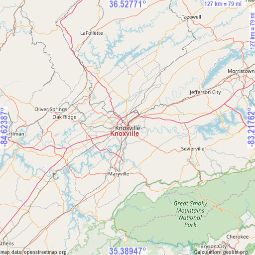
Knoxville GPS coordinates[2]
35° 57' 38.304" North, 83° 55' 14.664" West
| Map corner | latitude | longitude |
|---|---|---|
| Upper-left | 36.52771°, | -84.62387° |
| Center: | 35.96064°, | -83.92074° |
| Lower-right: | 35.38947°, | -83.21762° |
| Map W x H: | 126.6×126.6 km | = 78.7×78.7mi |
| max Lat: | 71.29058° ⇑70.6% North |
| Knoxville: | 35.96064° |
| min Lat: | ⇓29.4% South 19.06759° |
| min Long | Knoxville | max Long |
| -171.73463° | -83.92074° | -66.98998° |
| W 59.5%⇐ | ⇒40.5% E |
Elevation
Elevation of Knoxville is 277 m = 909 ft, and this is 17.8 m = 58 ft below average elevation for this country.
| Max E: |
3189 m = 10463 ft | 31.8% |
| Avg. | 294.8 m = 967 ft | |
| Knoxville | 277 m = 909 ft | |
Min E: |
-60 m = -197 ft | 68.2% |
See also: Knoxville elevation on elevation.city.
Geographical zone
Knoxville is located in North temperate zone (between Tropic of Cancer and the Arctic Circle). Distance of this Northern Tropic circle is 1392.5 km =865.3 mi to South.| Distance of | km | miles | from Knoxville |
|---|---|---|---|
| North Pole | 6008.6 | 3733.6 | to North |
| Arctic Circle | 3402.7 | 2114.3 | to North |
| Tropic Cancer | 1392.5 | 865.3 | to South |
| Equator | 3998.4 | 2484.5 | to South |


Nearby cities:
15 places around Knoxville: (largest is in red/bold)
• Alcoa
19.6 km =12.2 mi,  194°
194°
• Blaine
29 km =18 mi,  42°
42°
• Clinton
24.7 km =15.3 mi,  309°
309°
• Condon
27 km =16.8 mi,  24°
24°
• Eagleton Village
18.4 km =11.4 mi,  183°
183°
• Farragut
22.6 km =14 mi,  248°
248°
• Friendsville
29.5 km =18.3 mi,  221°
221°
• Louisville
19.2 km =11.9 mi, 216°
• Maryville
23.1 km =14.4 mi, 191°
• Mascot
19.3 km =12 mi,  54°
54°
• Norris
29.3 km =18.2 mi,  333°
333°
• Plainview
26.6 km =16.5 mi,  25°
25°
• Rockford
14.9 km =9.3 mi, 186°
• Seymour
19.3 km =12 mi,  113°
113°
• Wildwood
18 km =11.2 mi,  165°
165°
Sources, notices
• [Note1] Compared only with cities in United States existing in our database
• [Src1] Map data: © OpenStreetMap contributors (CC-BY-SA)
• [Src2] Other city data from geonames.org with taken over terms of usage.
• [Src3] Geographical zone / Annual Mean Temperature by Robert A. Rohde @ Wikipedia
