Wildwood geodata
Wildwood (Tennessee) is a populated place; located in United States in America/New_York (GMT-4) time zone. With population of 1,098 people, there are 15686 cities with bigger population in this country. Compared to other cities in United States, 71.3% of cities are located further ↑North; 59.6% of cities are located further ←West and 70.3% of cities have lower elevation than Wildwood. Note1


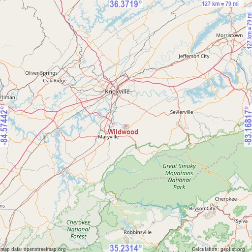
Wildwood GPS coordinates[2]
35° 48' 13.32" North, 83° 52' 16.644" West
| Map corner | latitude | longitude |
|---|---|---|
| Upper-left | 36.3719°, | -84.57442° |
| Center: | 35.8037°, | -83.87129° |
| Lower-right: | 35.2314°, | -83.16817° |
| Map W x H: | 126.8×126.8 km | = 78.8×78.8mi |
| max Lat: | 71.29058° ⇑71.3% North |
| Wildwood: | 35.8037° |
| min Lat: | ⇓28.7% South 19.06759° |
| min Long | Wildwood | max Long |
| -171.73463° | -83.87129° | -66.98998° |
| W 59.6%⇐ | ⇒40.4% E |
Elevation
Elevation of Wildwood is 287 m = 942 ft, and this is 7.8 m = 26 ft below average elevation for this country.
| Max E: |
3189 m = 10463 ft | 29.7% |
| Avg. | 294.8 m = 967 ft | |
| Wildwood | 287 m = 942 ft | |
Min E: |
-60 m = -197 ft | 70.3% |
See also: United States elevation on elevation.city.
Geographical zone
Wildwood is located in North temperate zone (between Tropic of Cancer and the Arctic Circle). Distance of this Northern Tropic circle is 1375.1 km =854.4 mi to South.| Distance of | km | miles | from Wildwood |
|---|---|---|---|
| North Pole | 6026.1 | 3744.4 | to North |
| Arctic Circle | 3420.2 | 2125.2 | to North |
| Tropic Cancer | 1375.1 | 854.4 | to South |
| Equator | 3981 | 2473.7 | to South |


Nearby cities:
15 places around Wildwood: (largest is in red/bold)
• Alcoa
9.4 km =5.8 mi,  260°
260°
• Eagleton Village
5.5 km =3.4 mi, 260°
• Farragut
27 km =16.8 mi,  289°
289°
• Friendsville
24.3 km =15.1 mi, 258°
• Gatlinburg
33.9 km =21.1 mi,  107°
107°
• Greenback
31.4 km =19.5 mi,  239°
239°
• Knoxville
18 km =11.2 mi,  345°
345°
• Lenoir City
34.7 km =21.6 mi,  268°
268°
• Louisville
16.1 km =10 mi,  277°
277°
• Maryville
10.4 km =6.5 mi, 239°
• Mascot
30.8 km =19.1 mi,  21°
21°
• Pigeon Forge
28.6 km =17.8 mi,  93°
93°
• Rockford
6.8 km =4.2 mi, 292°
• Sevierville
28.8 km =17.9 mi,  75°
75°
• Seymour
16.4 km =10.2 mi,  53°
53°
Sources, notices
• [Note1] Compared only with cities in United States existing in our database
• [Src1] Map data: © OpenStreetMap contributors (CC-BY-SA)
• [Src2] Other city data from geonames.org with taken over terms of usage.
• [Src3] Geographical zone / Annual Mean Temperature by Robert A. Rohde @ Wikipedia
