Eagleton Village geodata
Eagleton Village (Tennessee) is a populated place; located in United States in America/New_York (GMT-4) time zone. With population of 5,052 people, there are 7123 cities with bigger population in this country. Compared to other cities in United States, 71.4% of cities are located further ↑North; 59.5% of cities are located further ←West and 72.2% of cities have lower elevation than Eagleton Village. Note1


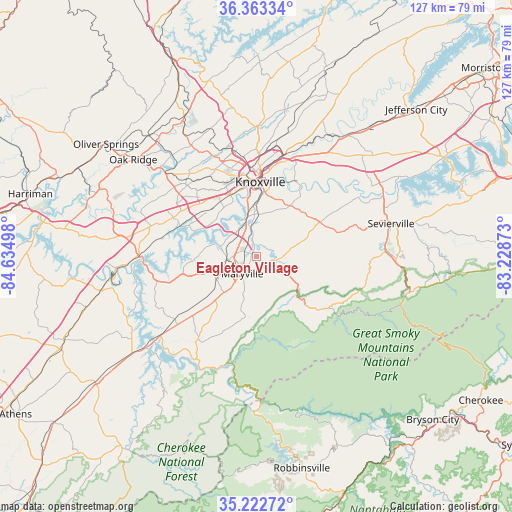
Eagleton Village GPS coordinates[2]
35° 47' 42.288" North, 83° 55' 54.66" West
| Map corner | latitude | longitude |
|---|---|---|
| Upper-left | 36.36334°, | -84.63498° |
| Center: | 35.79508°, | -83.93185° |
| Lower-right: | 35.22272°, | -83.22873° |
| Map W x H: | 126.8×126.8 km | = 78.8×78.8mi |
| max Lat: | 71.29058° ⇑71.4% North |
| Eagleton Village: | 35.79508° |
| min Lat: | ⇓28.6% South 19.06759° |
| min Long | Eagleton Villag | max Long |
| -171.73463° | -83.93185° | -66.98998° |
| W 59.5%⇐ | ⇒40.5% E |
Elevation
Elevation of Eagleton Village is 297 m = 974 ft, and this is 2.2 m = 7 ft above average elevation for this country.
| Max E: |
3189 m = 10463 ft | 27.8% |
| Eagleton Village | 297 m 974 ft | |
| Avg. | 294.8 m = 967 ft | |
Min E: |
-60 m = -197 ft | 72.2% |
See also: United States elevation on elevation.city.
Geographical zone
Eagleton Village is located in North temperate zone (between Tropic of Cancer and the Arctic Circle). Distance of this Northern Tropic circle is 1374.1 km =853.8 mi to South.| Distance of | km | miles | from Eagleton Village |
|---|---|---|---|
| North Pole | 6027 | 3745 | to North |
| Arctic Circle | 3421.1 | 2125.8 | to North |
| Tropic Cancer | 1374.1 | 853.8 | to South |
| Equator | 3980 | 2473.1 | to South |


Nearby cities:
15 places around Eagleton Village: (largest is in red/bold)
• Alcoa
3.8 km =2.4 mi,  260°
260°
• Farragut
22.3 km =13.9 mi,  296°
296°
• Friendsville
18.8 km =11.7 mi, 258°
• Greenback
26.3 km =16.3 mi,  235°
235°
• Huntsville
31.7 km =19.7 mi,  266°
266°
• Knoxville
18.4 km =11.4 mi,  3°
3°
• Lenoir City
29.2 km =18.1 mi, 270°
• Louisville
10.9 km =6.8 mi,  285°
285°
• Maryville
5.5 km =3.4 mi,  219°
219°
• Mascot
34 km =21.1 mi,  29°
29°
• Pigeon Forge
34.1 km =21.2 mi,  91°
91°
• Rockford
3.7 km =2.3 mi,  347°
347°
• Seymour
21.5 km =13.4 mi,  60°
60°
• Tellico Village
31.7 km =19.7 mi,  246°
246°
• Wildwood
5.5 km =3.4 mi,  80°
80°
Sources, notices
• [Note1] Compared only with cities in United States existing in our database
• [Src1] Map data: © OpenStreetMap contributors (CC-BY-SA)
• [Src2] Other city data from geonames.org with taken over terms of usage.
• [Src3] Geographical zone / Annual Mean Temperature by Robert A. Rohde @ Wikipedia
