Saint Joseph geodata
Saint Joseph (Tennessee) is a populated place; located in United States in America/Chicago (GMT-5) time zone. With population of 782 people, there are 17962 cities with bigger population in this country. Compared to other cities in United States, 75.2% of cities are located further ↑North; 50.8% of cities are located further →East and 61% of cities have lower elevation than Saint Joseph. Note1


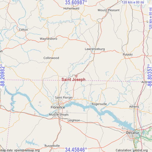
Saint Joseph GPS coordinates[2]
35° 2' 10.284" North, 87° 30' 24.084" West
| Map corner | latitude | longitude |
|---|---|---|
| Upper-left | 35.60987°, | -88.20982° |
| Center: | 35.03619°, | -87.50669° |
| Lower-right: | 34.45846°, | -86.80357° |
| Map W x H: | 128×128 km | = 79.5×79.5mi |
| max Lat: | 71.29058° ⇑75.2% North |
| Saint Joseph: | 35.03619° |
| min Lat: | ⇓24.8% South 19.06759° |
| min Long | Saint Joseph | max Long |
| -171.73463° | -87.50669° | -66.98998° |
| W 49.2%⇐ | ⇒50.8% E |
Elevation
Elevation of Saint Joseph is 244 m = 801 ft, and this is 50.8 m = 167 ft below average elevation for this country.
| Max E: |
3189 m = 10463 ft | 39% |
| Avg. | 294.8 m = 967 ft | |
| Saint Joseph | 244 m = 801 ft | |
Min E: |
-60 m = -197 ft | 61% |
See also: United States elevation on elevation.city.
Geographical zone
Saint Joseph is located in North temperate zone (between Tropic of Cancer and the Arctic Circle). Distance of this Northern Tropic circle is 1289.7 km =801.4 mi to South.| Distance of | km | miles | from Saint Joseph |
|---|---|---|---|
| North Pole | 6111.4 | 3797.4 | to North |
| Arctic Circle | 3505.5 | 2178.2 | to North |
| Tropic Cancer | 1289.7 | 801.4 | to South |
| Equator | 3895.7 | 2420.7 | to South |


Nearby cities:
15 places around Saint Joseph: (largest is in red/bold)
• Collinwood
26 km =16.2 mi,  306°
306°
• East Florence
28.4 km =17.6 mi,  207°
207°
• Florence
30.5 km =19 mi, 210°
• Killen
19.5 km =12.1 mi,  188°
188°
• Lawrenceburg
27.7 km =17.2 mi,  34°
34°
• Leighton
37.3 km =23.2 mi,  183°
183°
• Lexington
14.4 km =8.9 mi,  121°
121°
• Loretto
7.7 km =4.8 mi,  52°
52°
• Minor Hill
31.9 km =19.8 mi,  86°
86°
• Muscle Shoals
35.6 km =22.1 mi,  204°
204°
• Rogersville
30.2 km =18.8 mi,  140°
140°
• Sheffield
34.9 km =21.7 mi, 210°
• Tuscumbia
38.3 km =23.8 mi, 207°
• Underwood-Petersville
24.8 km =15.4 mi,  224°
224°
• Waynesboro
39.1 km =24.3 mi,  323°
323°
Sources, notices
• [Note1] Compared only with cities in United States existing in our database
• [Src1] Map data: © OpenStreetMap contributors (CC-BY-SA)
• [Src2] Other city data from geonames.org with taken over terms of usage.
• [Src3] Geographical zone / Annual Mean Temperature by Robert A. Rohde @ Wikipedia
