Underwood-Petersville geodata
Underwood-Petersville (Alabama) is a populated place; located in United States in America/Chicago (GMT-5) time zone. With population of 3,247 people, there are 9236 cities with bigger population in this country. Compared to other cities in United States, 76% of cities are located further ↑North; 51.4% of cities are located further →East and 50.5% of cities have higher elevation than Underwood-Petersville. Note1


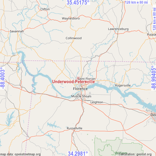
Underwood-Petersville GPS coordinates[2]
34° 52' 37.02" North, 87° 41' 49.812" West
| Map corner | latitude | longitude |
|---|---|---|
| Upper-left | 35.45175°, | -88.4003° |
| Center: | 34.87695°, | -87.69717° |
| Lower-right: | 34.2981°, | -86.99405° |
| Map W x H: | 128.3×128.3 km | = 79.7×79.7mi |
| max Lat: | 71.29058° ⇑76% North |
| Underwood-Petersville: | 34.87695° |
| min Lat: | ⇓24% South 19.06759° |
| min Long | Underwood-Peter | max Long |
| -171.73463° | -87.69717° | -66.98998° |
| W 48.6%⇐ | ⇒51.4% E |
Elevation
Elevation of Underwood-Petersville is 196 m = 643 ft, and this is 98.8 m = 324 ft below average elevation for this country.
| Max E: |
3189 m = 10463 ft | 50.5% |
| Avg. | 294.8 m = 967 ft | |
| Underwood-Petersville | 196 m = 643 ft | |
Min E: |
-60 m = -197 ft | 49.5% |
See also: United States elevation on elevation.city.
Geographical zone
Underwood-Petersville is located in North temperate zone (between Tropic of Cancer and the Arctic Circle). Distance of this Northern Tropic circle is 1272 km =790.4 mi to South.| Distance of | km | miles | from Underwood-Petersville |
|---|---|---|---|
| North Pole | 6129.1 | 3808.4 | to North |
| Arctic Circle | 3523.2 | 2189.2 | to North |
| Tropic Cancer | 1272 | 790.4 | to South |
| Equator | 3878 | 2409.7 | to South |


Nearby cities:
15 places around Underwood-Petersville: (largest is in red/bold)
• Cherokee
28.5 km =17.7 mi,  242°
242°
• Collinwood
33.3 km =20.7 mi,  353°
353°
• East Florence
8.7 km =5.4 mi,  149°
149°
• Florence
8.8 km =5.5 mi,  168°
168°
• Killen
14.6 km =9.1 mi,  96°
96°
• Leighton
24.9 km =15.5 mi,  141°
141°
• Lexington
31.4 km =19.5 mi,  70°
70°
• Littleville
31.9 km =19.8 mi,  176°
176°
• Loretto
32.4 km =20.1 mi,  46°
46°
• Muscle Shoals
14.9 km =9.3 mi, 169°
• Rogersville
37 km =23 mi, 98°
• Saint Joseph
24.8 km =15.4 mi,  44°
44°
• Sheffield
12.4 km =7.7 mi, 180°
• Town Creek
34.4 km =21.4 mi,  129°
129°
• Tuscumbia
16.2 km =10.1 mi, 181°
Sources, notices
• [Note1] Compared only with cities in United States existing in our database
• [Src1] Map data: © OpenStreetMap contributors (CC-BY-SA)
• [Src2] Other city data from geonames.org with taken over terms of usage.
• [Src3] Geographical zone / Annual Mean Temperature by Robert A. Rohde @ Wikipedia
