Spring Hill geodata
Spring Hill (Tennessee) is a populated place; located in United States in America/Chicago (GMT-5) time zone. With population of 36,055 people, there are 1359 cities with bigger population in this country. Compared to other cities in United States, 71.5% of cities are located further ↑North; 50.4% of cities are located further ←West and 58.2% of cities have lower elevation than Spring Hill. Note1


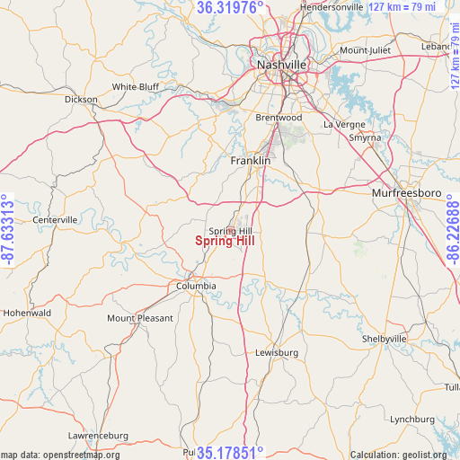
Spring Hill GPS coordinates[2]
35° 45' 4.248" North, 86° 55' 48" West
| Map corner | latitude | longitude |
|---|---|---|
| Upper-left | 36.31976°, | -87.63313° |
| Center: | 35.75118°, | -86.93° |
| Lower-right: | 35.17851°, | -86.22688° |
| Map W x H: | 126.9×126.9 km | = 78.9×78.9mi |
| max Lat: | 71.29058° ⇑71.5% North |
| Spring Hill: | 35.75118° |
| min Lat: | ⇓28.5% South 19.06759° |
| min Long | Spring Hill | max Long |
| -171.73463° | -86.93° | -66.98998° |
| W 50.4%⇐ | ⇒49.6% E |
Elevation
Elevation of Spring Hill is 231 m = 758 ft, and this is 63.8 m = 209 ft below average elevation for this country.
| Max E: |
3189 m = 10463 ft | 41.8% |
| Avg. | 294.8 m = 967 ft | |
| Spring Hill | 231 m = 758 ft | |
Min E: |
-60 m = -197 ft | 58.2% |
See also: United States elevation on elevation.city.
Geographical zone
Spring Hill is located in North temperate zone (between Tropic of Cancer and the Arctic Circle). Distance of this Northern Tropic circle is 1369.2 km =850.8 mi to South.| Distance of | km | miles | from Spring Hill |
|---|---|---|---|
| North Pole | 6031.9 | 3748 | to North |
| Arctic Circle | 3426 | 2128.8 | to North |
| Tropic Cancer | 1369.2 | 850.8 | to South |
| Equator | 3975.2 | 2470.1 | to South |


Nearby cities:
15 places around Spring Hill: (largest is in red/bold)
• Belle Meade
38.9 km =24.2 mi,  9°
9°
• Bon Aqua Junction
39.6 km =24.6 mi,  299°
299°
• Brentwood
34 km =21.1 mi,  22°
22°
• Brentwood Estates
33.3 km =20.7 mi, 24°
• Chapel Hill
25.5 km =15.8 mi,  122°
122°
• Columbia
17.9 km =11.1 mi,  212°
212°
• Eagleville
25.3 km =15.7 mi,  92°
92°
• Fairview
30.9 km =19.2 mi,  326°
326°
• Forest Hills
36.1 km =22.4 mi, 12°
• Franklin
20.1 km =12.5 mi, 15°
• Lewisburg
35.9 km =22.3 mi,  159°
159°
• Mount Pleasant
34.8 km =21.6 mi,  226°
226°
• Nolensville
32.4 km =20.1 mi,  46°
46°
• Thompson's Station
5.9 km =3.7 mi, 16°
• Unionville
33.7 km =20.9 mi, 115°
Sources, notices
• [Note1] Compared only with cities in United States existing in our database
• [Src1] Map data: © OpenStreetMap contributors (CC-BY-SA)
• [Src2] Other city data from geonames.org with taken over terms of usage.
• [Src3] Geographical zone / Annual Mean Temperature by Robert A. Rohde @ Wikipedia
