Brentwood geodata
Brentwood (Tennessee) is a populated place; located in United States in America/Chicago (GMT-5) time zone. With population of 41,763 people, there are 1149 cities with bigger population in this country. Compared to other cities in United States, 70.3% of cities are located further ↑North; 50.8% of cities are located further ←West and 58.2% of cities have lower elevation than Brentwood. Note1


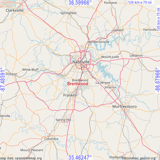
Brentwood GPS coordinates[2]
36° 1' 59.232" North, 86° 46' 58.008" West
| Map corner | latitude | longitude |
|---|---|---|
| Upper-left | 36.59966°, | -87.48591° |
| Center: | 36.03312°, | -86.78278° |
| Lower-right: | 35.46247°, | -86.07966° |
| Map W x H: | 126.4×126.4 km | = 78.5×78.5mi |
| max Lat: | 71.29058° ⇑70.3% North |
| Brentwood: | 36.03312° |
| min Lat: | ⇓29.7% South 19.06759° |
| min Long | Brentwood | max Long |
| -171.73463° | -86.78278° | -66.98998° |
| W 50.8%⇐ | ⇒49.2% E |
Elevation
Elevation of Brentwood is 231 m = 758 ft, and this is 63.8 m = 209 ft below average elevation for this country.
| Max E: |
3189 m = 10463 ft | 41.8% |
| Avg. | 294.8 m = 967 ft | |
| Brentwood | 231 m = 758 ft | |
Min E: |
-60 m = -197 ft | 58.2% |
See also: Brentwood elevation on elevation.city.
Geographical zone
Brentwood is located in North temperate zone (between Tropic of Cancer and the Arctic Circle). Distance of this Northern Tropic circle is 1400.6 km =870.3 mi to South.| Distance of | km | miles | from Brentwood |
|---|---|---|---|
| North Pole | 6000.6 | 3728.6 | to North |
| Arctic Circle | 3394.7 | 2109.4 | to North |
| Tropic Cancer | 1400.6 | 870.3 | to South |
| Equator | 4006.5 | 2489.5 | to South |


Nearby cities:
15 places around Brentwood: (largest is in red/bold)
• Belle Meade
9.7 km =6 mi,  316°
316°
• Berry Hill
9.4 km =5.8 mi,  8°
8°
• Brentwood Estates
1 km =0.6 mi,  160°
160°
• Forest Hills
6.8 km =4.2 mi,  305°
305°
• Franklin
14.3 km =8.9 mi,  212°
212°
• Green Hill
29.7 km =18.5 mi,  44°
44°
• La Vergne
18.2 km =11.3 mi,  96°
96°
• Lakewood
26.8 km =16.7 mi,  29°
29°
• Nashville
14.8 km =9.2 mi,  359°
359°
• Nolensville
13.6 km =8.5 mi,  131°
131°
• Oak Hill
6.1 km =3.8 mi, 359°
• Pegram
25.3 km =15.7 mi,  287°
287°
• Rural Hill
28.8 km =17.9 mi,  71°
71°
• Smyrna
24.4 km =15.2 mi, 103°
• Thompson's Station
28.2 km =17.5 mi,  204°
204°
Sources, notices
• [Note1] Compared only with cities in United States existing in our database
• [Src1] Map data: © OpenStreetMap contributors (CC-BY-SA)
• [Src2] Other city data from geonames.org with taken over terms of usage.
• [Src3] Geographical zone / Annual Mean Temperature by Robert A. Rohde @ Wikipedia
