Columbia geodata
Columbia (Tennessee) is a seat of a second-order administrative division; located in United States in America/Chicago (GMT-5) time zone. With population of 36,800 people, there are 1324 cities with bigger population in this country. Compared to other cities in United States, 72.1% of cities are located further ↑North; 50.2% of cities are located further ←West and 50.2% of cities have lower elevation than Columbia. Note1


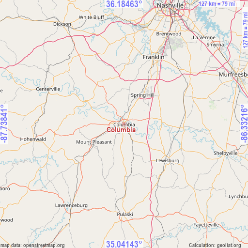
Columbia GPS coordinates[2]
35° 36' 54.252" North, 87° 2' 7.008" West
| Map corner | latitude | longitude |
|---|---|---|
| Upper-left | 36.18463°, | -87.73841° |
| Center: | 35.61507°, | -87.03528° |
| Lower-right: | 35.04143°, | -86.33216° |
| Map W x H: | 127.1×127.1 km | = 79×79mi |
| max Lat: | 71.29058° ⇑72.1% North |
| Columbia: | 35.61507° |
| min Lat: | ⇓27.9% South 19.06759° |
| min Long | Columbia | max Long |
| -171.73463° | -87.03528° | -66.98998° |
| W 50.2%⇐ | ⇒49.8% E |
Elevation
Elevation of Columbia is 199 m = 653 ft, and this is 95.8 m = 314 ft below average elevation for this country.
| Max E: |
3189 m = 10463 ft | 49.8% |
| Avg. | 294.8 m = 967 ft | |
| Columbia | 199 m = 653 ft | |
Min E: |
-60 m = -197 ft | 50.2% |
See also: United States elevation on elevation.city.
Geographical zone
Columbia is located in North temperate zone (between Tropic of Cancer and the Arctic Circle). Distance of this Northern Tropic circle is 1354.1 km =841.4 mi to South.| Distance of | km | miles | from Columbia |
|---|---|---|---|
| North Pole | 6047 | 3757.4 | to North |
| Arctic Circle | 3441.1 | 2138.2 | to North |
| Tropic Cancer | 1354.1 | 841.4 | to South |
| Equator | 3960 | 2460.6 | to South |


Nearby cities:
15 places around Columbia: (largest is in red/bold)
• Bon Aqua Junction
42.7 km =26.5 mi,  324°
324°
• Centerville
43 km =26.7 mi,  295°
295°
• Chapel Hill
30.9 km =19.2 mi,  87°
87°
• Cornersville
33.3 km =20.7 mi,  147°
147°
• Eagleville
37.6 km =23.4 mi,  67°
67°
• Fairview
41.5 km =25.8 mi,  349°
349°
• Franklin
37.6 km =23.4 mi,  23°
23°
• Lewisburg
28.9 km =18 mi,  129°
129°
• Lyles
43.9 km =27.3 mi, 320°
• Mount Pleasant
17.9 km =11.1 mi,  239°
239°
• Pulaski
46.2 km =28.7 mi,  179°
179°
• Spring Hill
17.9 km =11.1 mi,  32°
32°
• Summertown
32.1 km =19.9 mi,  231°
231°
• Thompson's Station
23.6 km =14.7 mi, 28°
• Unionville
40 km =24.9 mi, 88°
Sources, notices
• [Note1] Compared only with cities in United States existing in our database
• [Src1] Map data: © OpenStreetMap contributors (CC-BY-SA)
• [Src2] Other city data from geonames.org with taken over terms of usage.
• [Src3] Geographical zone / Annual Mean Temperature by Robert A. Rohde @ Wikipedia
